News
Spiti Valley in a Honda Amaze with 1.23 lakh km on the odometer
Two of my friends wanted to ride to Spiti, so they rented a bike from Chandigarh rest two, including myself, in the Honda Amaze.
BHPian MuditP recently shared this with other enthusiasts.
From City Streets to Spiti Peaks: A Honda Amaze Odyssey
Hello fellow BHPians, I embarked on a journey to cover the full Spiti circuit in a Honda Amaze 1.2 SMT, this is my travelogue of the adventurous journey I covered, I am sorry if this travelogue is a bit long but a Spiti Valley Circuit travelogue deserves no less, I have tried to be as detailed as possible. This is my first post on the forum, so if I make any mistake, Mods please let me know.
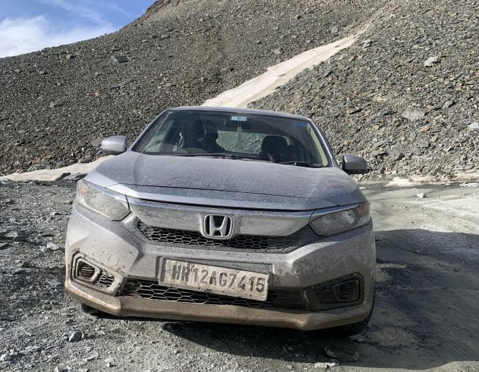
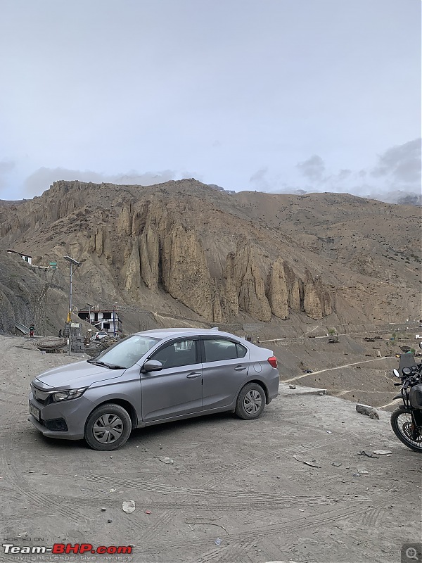
A little background first, I am 21 years old, I and my three friends planned to go to Spiti last year in July but could not due to landslides and heavy rainfall just before the day we were supposed to leave, cut to April 2024, and decided to cover the full Spiti circuit in the first week of June. The plan was to enter Spiti from the Shimla side and exit via Manali; however, NH 505 (Lossar-Koksar) was not opened until the very last moment, but we all decided to go to Spiti with the hope that NH 505 would be opened for 4×2 cars by the time we reach Kaza. Two of my friends wanted to ride to Spiti, so they rented a bike from Chandigarh rest two, including myself, in the Honda Amaze. The car is a 2018 2nd Generation Honda Amaze (S) Petrol Manual and had done over 1.23 Lakh Km before starting the trip.
The modifications performed were as follows:
- Tyres Upgraded from 175/65 R14 to 185/70 R14 (done in Initial years of ownership)
- Aftermarket Blaupunkt KeyLargo 980 Andriod Headunit
Preparation for car:
- Standard Service which included a change of spark plugs,
- Coolant flushed out and replaced with -10 oC rated coolant,
- Extra set of Headlight bulbs,
- Made a kit with 3M double-side tape, zip ties, a pair of scissors, a cutter, a Puncture repair kit, tow rope, spanners, a screwdriver, and other basic tools,. Checked portable Air compressor (is always placed in the car),
- Took a few tyre air valves.
Brief Itinerary
- Day 1: Rohtak to Chitkul
- Day 2: Chitkul to Tabo
- Day 3: Tabo to Kaza
- Day 4: Sightseeing in Kaza
- Day 5: Kaza to Manali
- Day 6: Manali to Rohtak.
DAY 1: Rohtak to Chitku
We started early around 5 AM on 3rd July the day was rather uneventful with frequent jams on the highway as it was tourist season, the dreaded Zirakpur jam took us close to one and half hours to cross, with such high traffic flow I decided to skip Shimla entirely and took a diversion just before Kandaghat toward Sadhupul and chail, it’s a well paved single lane state highway which bypasses all the traffic going towards Shimla and leads to Sadhupul from where one can go to Chail or Kufri (Via Junga) we took the road towards Kufri from Junga and Joined back on the NH5 this saved us approximately half an hour and a lot of traffic.
It started drizzling after Narkanda and the hills came to life with lush greenery and clean well paved roads, it was all very beautiful and serene, just after crossing Narkanda around 160 km before Chitkul it started raining heavily due to which the speed reduced to 15-20 KMPH, we took our first viewpoint stop near Rampur Bushar it had stopped raining and it was around 6 PM, Chitkul was still a good 99KM away and google maps showed ETA as 3 hours, (however it took us 3 hours just to reach Karcham Dam).
After reaching Karcham around 9 PM we asked the Zostel reception if it was safe to travel in the dark till Chitkul, they said it was safe to travel but would take 3 to 4 hours due to the bad condition of the road, we continued ahead to reach our destination Zostel Chitkul, and the road indeed is quite bad it is not paved at all, it’s all rocky and the speed of the car did not exceed 20KMPH, we encountered 2 goat attacks which slowed us down further but as we were climbing up to the last village of India the temperature was dropping faster than we were attaining height, we reached Zostel in the night around 11:30,
As we got out of the car we quickly realised how cold and windy it actually is, our phones showed -1 *C but it surely felt much lower than that, there was a bonfire going on we sat around it for a bit had our dinner, and called it a night. It was enough adventure for us on the first day, the road from Karcham to Chitkul gave us a trailer of what to expect in the coming days.

DAY 2: Chitkul to Tabo
We were so high on adrenaline that 5 hours of sleep completely refreshed us, we woke up at 5 am to witness the sunrise, it was very peaceful and pretty all around, with Lush green mountains on both sides the sound of water from the river and snowcapped mountains which were so close we thought we could walk up to them, it all felt like the drawings we drew in childhood with the sun rising between two mountains and river coming through them, but we could not see the sunrise because of heavy clouds, we were up and it was all so beautiful that we decided to go on a stroll through the village, it was all very calming and silent, everything was closed and only a few locals were up at that time, we walked through the entire village and then decided to go to the river bank, spent some time near river, came back to our dorm, got ready and left for the adventure ahead.

We descended to Karcham dam and were finally back on a smooth mettled road, we planned on going to Kalpa as our first stop for the day our friends on the bike were a few kms ahead of us and told us that there was no fuel left at the reckoning peo petrol bunk, coincidentally we were in Powri at that moment where the last fuel station is before reckoning peo, we tanked up and also filled up the 5L jerry can.
We went to Kalpa but could not the peak of mighty Kinner Kailash as clouds had covered it up completely, Had lunch in reckong peo and continued ahead, it started drizzling and it was windy it was cold the scent of soil after rains, the well maintained two lane highway everything added up to enhance our experience and it was all very beautiful (Could not stress this enough),we cruised at 50-60KMPH and the scenery started to change from lush green mountains to rocky barren mountains.
We crossed Pooh where the last petrol pump is before Kaza, there was a huge line of vehicles here as reckong peo were out of fuel, but we didn’t need to stop at Pooh because our vehicles were topped up at Powri, we continued past pooh enjoying our playlist and reached Dabling where the first check post came, the officials asked one of us to make the entry.
In a few minutes, we were at Khab Sangam Bridge it is the confluence of the Spiti and Sutlej Rivers, we stopped here for a bit for photos.

We were so mesmerised by the view and enjoying the drive so much that we missed the turn towards Nako village and crossed Malling Nala the water flow here was very less this time, and after crossing it we realised that we missed the turn towards Nako, we decided to head back around 8km because we didn’t want to leave anything, we reached Nako lake and well I would say it is overhyped.
Anyway we continued towards Tabo (our stay for the night) and well this time the Malling Nalla was roaring with water flow we managed to cross it again without much issue. There were quite a few steep hairpin bends after the nalla, and I must say the car performed incredibly with full luggage in the boot and on the rear bench Amaze climbed up very easily, the speed was slow had to keep the car in 1st gear on the hairpins; After Nako the scenery changed, there was no vegetation at all and hardly any people we would see a car once in a while, it was just the barren mountains and us four.
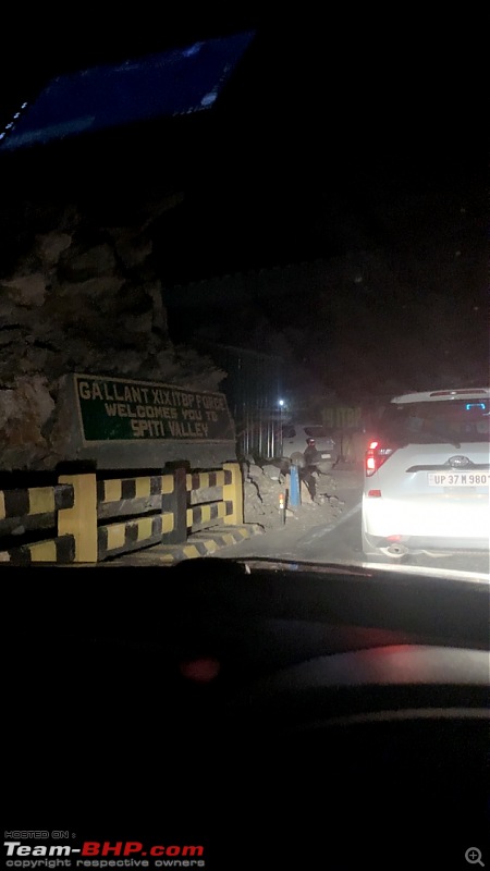
We entered the Spiti Valley at night around 8:30, there was a check post at Sumdo which is the gate to Spiti Valley and they made an entry for us, we stopped at the check post for a bit celebrating that we had finally made it to Spiti valley.
After entering Spiti Valley the roads changed up until now there were two-lane roads and now the roads have become much narrower into single-lane ones, however they were well paved with a few patches of rocky road.
Just 10 Km before Tabo we found ourselves in a bit of a situation where the road turned into a river bed of sorts, there was no water but it was covered with loose stones, it was pitch black and we could only see through the high beam of our car there was no one else and we couldn’t even see much through the flash of our phones, we decided to get down and inspect the road on foot but the stones were so weak and loose that our feet were kind of sinking while walking.
Honestly, we could not see how any vehicle could go through the road Google Maps was showing, we called our homestay owner and told him about this, he told us to cross it and that every vehicle crosses it without any problem, we were not sure that anyone could cross that stretch and we couldn’t see any alternate route so we decided to give it a try we took our vehicles on that gravel a few feet ahead and quickly realised that the route google is showing could not be accurate as now we can see a steep climb covered with loose gravel, we turned around our vehicles and decided to head back told our homestay owner that we are not coming in the night. Thankfully the car did not get stuck in those stones.
As we turned around, we saw a local tempo coming towards us, we asked him the way to Tabo he told us that the road was on the left side and where we were standing is a Nalla, he told us to follow him as he also was headed to Tabo. If the tempo had not arrived at the right time, we would not have made it to Tabo. Lesson Learned: Never trust Google Maps on mountains.
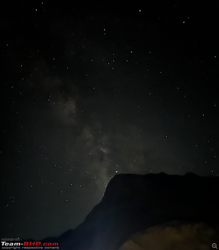
We reached Tabo in about 20 minutes from that spot, checked in to our homestay, and straight up went to the roof to stargaze, but to our surprise there were no stars in the sky then our homestay owner told us that stars are visible after 1 AM we stayed up late, went to the roof around 1:30 AM, and we were awestruck; I had not seen such a beautiful sky studded with stars, we immediately tried to capture it with our phones but the photos could not do justice to what our eyes were witnessing so we just sat there for 2-3 hours gazing at the starry sky.
DAY 3: Tabo to Kaza
Day 3 was a relaxed day for us, there were only a few things on the itinerary for today, we started the day by heading back towards Sumdo to visit Gue Village as we could not visit it the previous day due to being late, The road which goes to Gue Village after leaving NH 505 is a steep climb till Gue and there is no tarmac it’s all rocky road.
Well, Gue is around 1 hour from Tabo and after reaching there some of our phones started picking up the Beijing Time zone, the time zone change shocked us at first because there was a traffic jam of sorts just before gue as a military truck was coming down on the single lane road, we saw the phone upon reaching Gue Monastery and saw the time being shown as 3 pm, we questioned ourselves did the jam last for 3 hours, then we realised the time zone is wrong.
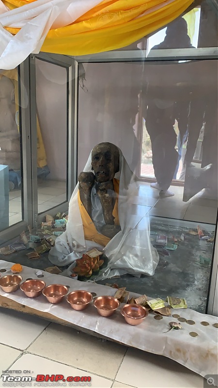
My phone with Airtel sim was the only one having an Indian time zone as only Airtel signals were there in Gue, coming back to monastery it was so beautiful and colorful, the view from there was amazing. The most interesting and famous thing about the monastery is that the Mummy of a Buddhist monk (Sangha Tanzin) is kept here, and it has been in the same posture since 1430 A. d. and nothing is used for its preservation.
After that, we went inside the main hall of the monastery and it was just as pretty as the exterior. After spending some time, we came back to Tabo and visited the Tabo Monastery, the old monastery here was established in 996 A.D. and after entering it feels like we have been teleported to Egypt or somethings, its all made from wood and mud the whole compound feels like a different place it is not like any other monastery we had seen, there were around 7 or 8 temples inside the compound of the monastery not all were open but 2-3 were open for visitors, photography is not allowed inside, once you enter the main temple you’ll notice that everything is made from wood and the ceiling height is low.
All the walls inside are filled with murals, even the ceiling, there are various statues inside, and the strange thing one notices is that there is no light inside the old temples, it’s all very dark. Only a small amount of daylight enters through a small opening on the ceiling. Adjacent to the old monastery is the newly built Tabo monastery, where all the monks reside and teachings happen.

After exploring both monasteries me and one of my friends were hungry and tired so we split up and decided to order lunch as a restaurant nearby while the rest two went to the caves which were a steep uphill climb across the road.
After they came back and a late lunch, we finally left Tabo for Dhankar Monastery, which was around 1 h away; the views were amazing there was a constant dilemma whether to stop the car and take it all in or cover the distance; our phone storage was filled with all the beautiful pictures taken every kilometre and we had to delete a lot of them because it was only day 3 and we needed space for more pictures.
However, through our eyes, none of the photos is as beautiful as it was in real life; there is just something in those landscapes that the cameras cannot capture. On the way we encountered a lot of shooting stones, two stones did hit our car but thankfully both were very small and only left a minor dent nothing more, and finally reached Dhankar Monastery just in time before its closing, we were one of the last ones to enter the monastery.
The monastery is built like a fort, there are various rooms which serves different purposes, there is a balcony in the monastery from which one can see the view of the valley and the view is just next to none, it’s so pretty it’s so beautiful, the naturally carved stones made us feel like it’s another planet altogether. After witnessing the picturesque landscape of spiti from Dhankar Monastery we started our journey towards the main town of Spiti Valley – Kaza.
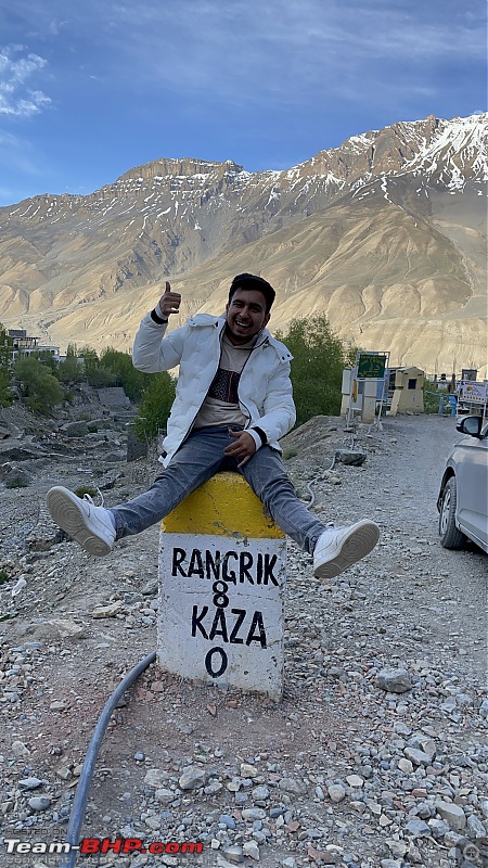
A local guided us to the route to kaza, which was different from what was being shown on our maps, but having no trust over Google Maps, we followed the route told by a local. Most of the roads in the Spiti valley are unpaved and rocky and this too was the same, the suspension of car really took some serious beating on this trip.
We reached kaza around 8:30 and man it was packed, there was not even space to walk in the market; thankfully, we had already booked our homestay in advance, but the prior booking was of only one room and two people we tried to find another stay option, but it was all super packed there was no room available anywhere in kaza We requested our homestay owner to accommodate four of us and she happily agreed.
I asked her about the timing and availability of petrol in Kaza, and she told me that generally it is readily available, but today one of the machines has malfunctioned and is not dispensing petrol, we decided not to join the long queue at the fuel station at night and not to worry about it much as it probably would be resolved by the next day we then went to have dinner at The Himalayan Café
DAY 4: Kaza
I woke up at 7am and instantly went to the fuel station, I expected some wait time but the queue at the fuel station was insane, everyone was waiting in line for their turn or so I thought, after a good half an hour the queue was still at the same spot, I then went to ask about the delay and get some information on the situation and the chaos inside the fuel station was insane.
Diesel was readily available but petrol was not, there were four Petrol bunks three of them had no fuel in them and the 4th one was not working properly it would run for 5-10 minutes and then the motor would overheat and stop dispensing petrol.
Everyone there kept coming with jerry can get them filled and poured it into their cars, which were way behind in the line. The situation was that jerry cans were being filled first then some bikes and cars were left as it is, cars were hardly moving, and in my whole time, there were only three cars able to get petrol directly from the bunk.
So I called my friends asked them to borrow some jerry cans from homestay and come on bike to the fuel station, but by the time they came the situation became even more chaotic and no one seemed to follow queue system anymore, both the entry and exit points of fuel stations were blocked by cars, bikes, people with jerry cans and no one could move even the main road was blocked due to this, diesel dispensing was halted due to this chaos as diesel cars weren’t able to get to the bunk.
Police was called to clear some of the traffic on the road and maintain some order in the fuel station, after an hour or so I asked the manager of the pump about the situation he told me that 3 tankers of petrol are en route and will reach kaza by afternoon, and they had no idea when the faulted machine would be fixed so with no luck getting petrol even in jerry cans, we decided it’s not worth it to spend more time staying here and wasting the day, we had enough fuel in our car and bike to do all the sightseeing today and come back to kaza.
Plus, we had 5L extra fuel in jerry can for emergency use. We left the fuel station at 11Am got dressed up ready to explore the valley, first we headed to Café Piti(Ambience was very good it was very instaworthy but food was not) in the main market in kaza for brunch as we hadn’t eaten anything and the diesel fumes were giving me a headache, had something to eat, took medicine and went on to explore the 3 main villages Langza, Komic and Hikkim.
Langza: this is a village about 16km away from Kaza which takes around 30-40Minutes to reach, it is also known as the fossil village as a lot of fossils are found here but the main attraction here is the Buddha Statue near Langza Gompa, it is a huge golden coloured Buddha statue overlooking the valley.
It looks like that the Buddha is protecting and monitoring the valley and its mortal beings, with the elevation of 14,500 feet AMS is common in travellers here, two of us also suffered from it, even our vehicles were breathless and weren’t getting enough oxygen, the lack of power could be felt in the last leg when we were just about to reach the Buddha Statue.
The view from here is wonderful, but breathlessness got the better of us and we decided to leave quickly. By now, the bike had run out of fuel, and we used our 5L emergency petrol.

Komic: While coming back from Langza just on the turn for Komic, there is a shack (The Fossil Cafe) and we halted there for some pahadon wali Maggi, the shack was on the side of the road overlooking the valley and the Buddha statue, and the view was spot on, the winds were strong too.
Even while having Maggi, we were getting out of breath such was the gust of wind. At an elevation of 4587m (15,000 Feet) and a population of just 114, Komic is the highest village in the world connected with motorable road; the road to Komic was buttery smooth, with zero rocks and zero potholes, it felt like a freshly laid tarmac and was very strange as by now were accustomed to the uneven rocky roads and the noise of suspension.
The Main attraction here is the Komic Monastery and the Museum attached to it, Fossils collected from Langza are kept in the museum, it is a small monastery but we weren’t allowed to explore much as the prayers were going on. We went to the museum, and this was the first time I was seeing fossils in real life. I even got to hold one of them, and it was quite heavy.
The monastery is also at the highest point of the village, so it gives a good view of the village, and we just sat on the boundary wall soaking in the view, not worrying about anything clearing our minds it was very peaceful. And I could have sat there for hours! There is a restaurant immediately next to the monastery in the same parking lot, which claims to be the world’s highest restaurant. We also saw a café that claimed to be the world’s highest café on the way to komic, but it was closed.

Hikkim: We came down towards kaza and at the Y intersection we turned towards Hikkim and the road became terrible instantly we were spoilt by the good roads of Komic, Unpaved rocky road with dust in the air and a steep climb, the road screamed that it’s the way to a remote village in a remote valley.
It took us a good one hour to reach Hikkim from Komic. At an elevation of 4440m (14567 Feet), Hikkim is home to the world’s Highest Post Office. We reached here at around 7pm and the post office was closed by then there was only the owner of the shop in front of post office at that time expect us there were no tourists. The shop owner sold postcards, pens, souvenirs, and some basic foods such as maggi, tea, etc.
The owner also took postcards from tourists who were late and missed the working hours of the post office like us, and assured them to post them the next day when the post office opened. We all wrote some postcards and sent them to our home and loved ones, the shop owner told that one can send postcards internationally as well from here and it take INR 30 to do so, we decided to give it a shot and check the service, with no hope of the postcard getting delivered internationally we posted one to our friend’s address in Glasgow, Scotland.
Fun Fact: None of the postcards we sent to our homes in Delhi NCR have been delivered yet, but the one we sent to Glasgow was delivered on July 3, 2024, and it was in perfect condition with no crumbles or tears.
The shop owner told us that the route we took from Komic is the longer route, and there is a short route available between Komic and Hikkim, through which the distance is only 3 km and hardly takes 10/15 minutes. And we got played by Google maps again.


Then we received a call from our homestay owner that the Fuel station machines are up and running and they are dispensing petrol. We quickly rushed to kaza and again the line was quite long but hey at least now there was availability of petrol, everyone was still using the jerry can method to fill up cars so we did the same, Bike was filled directly through the pump and we filled 25L of fuel in car by jerry cans, a Jerry can with 8L petrol was kept aside for emergency use and the rest of the car tank was filled up directly at the pump as they refused to give us more fuel in jerry can.
Just as we were exiting the fuel station, a person told us that one of the tyres had gone flat, We filled some air and managed to take the car to a tyre shop just near the fuel station.
With the fuel tanks topped up, tyres checked, and all other fluid levels of vehicles checked, we were ready to face any and all the adventures that awaited us on the Lossar to Manali route the next day.
DAY 5: Kaza to Manali, we all woke up early at 5Am as we had a lot to cover today, we thought we all will take a bath but with temperature being -3 °C and Water heater not working due to no electricity bath was out of question so we left our Kaza Homestay at 6am straight up went to Key Monastery.
We reached key at 7AM which was the opening time of monastery and we were right on schedule, we were the first ones there, the Monk in the monastery offered us herbal tea which is supposed to help us breathe much more easily at higher altitudes, We left key monastery and continued towards the Chicham bridge, this bridge at an elevation of 13576 Feet is said to be the Asia’s Highest Bridge it connects chicham village to kibber village. When you look down from the bridge there, you will see an approximately 500 feet gorge.

We had breakfast here from one of the many food trucks. After this, we headed on towards Lossar and in between a patch of Kibber wildlife Sanctuary came the wildlife sanctuary with properly paved roads, in contrast to the unpaved dirt roads we have been driving over until now. We saw a vast grassland where a few yaks were playing.
We stopped there to click some pictures and take in the views but quickly realized that yaks were too close and could attack us at any moment, so we left towards lossar; the paved roads ended with the kibber sanctuary and we were back on to the dirt roads. By now, we were tired of the dirt roads, little did we know that we will miss these dirt roads and call them perfect roads by the end of the day.

Lossar – Kunzum La Pass We reached the Lossar check point at exactly 10:50Am, ITBP official at check post cautioned us that the road is very treacherous and dangerous with a lot of water crossing our Honda Amaze might get stuck, and we won’t have any cellular or GPS signal after crossing the check post until Koksar he told us that it takes around 8-10 hours to reach Koksar if one does not take a stop at Chandrataal and it might take 12-13 hours if Stopped at Chandrataal, he told us that hatchbacks have gone through the route, but he has not seen any sedan cross this section in this tourist season, but to be fair, the road from Lossar to Koksar was opened for 4×2 cars on June 2, 2024, and we were there on June 7 2024.
With that in mind he asked us to call our parents to let them know that there will not be any cellular signal for 10-12 hours. Google Maps failed us here again; Maps says that it takes three hours to reach Manali from Lossar and we had planned accordingly, but it takes around 10-12 hours.
After providing the details at the check post and informing our parents, we set to begin the adventure of a lifetime, crossing the most treacherous road, the road from Lossar to Koksar. We checked our tyres one last time and left the check point at exactly 11:05 AM and started our climb to Kunzum La and surely enough just after crossing the check post all our sim cards lost cellular signals, and even the offline downloaded Google Maps went nuts and after some time showed our location in the sea.
However, the landscape was magnificent; although the road was treacherous and scared us a bit, we enjoyed every bit of it. The road widening project is going on the Lossar to Kunzum La section, and most of it has been done so it was a two-lane road that made things easier, as there was ample space on the road.
The initial few kilometres felt really easy and we though that id this is the road all the way through then we got no problem and Amaze can handle it all without any trouble, but this feeling was short-lived as within 15 minutes we encountered a wooden bridge which we had to cross but it was broken and there is no way a car could go through it maybe bike would but that would involve a lot of risk, the other option was to cross the water crossing just beside it, water level here was not high but the stones were big and slippery, also it was technically our first major water crossing after Malling nallah, so I didn’t have much experience we though that Amaze might not be able to cross it without hitting any stone on underbody but we obviously decided to first give it a try, I got down looked at the crossing for a minute figured out a path which avoids big stones, got in the car put it in first gear and held the steering tight so it doesn’t skid and with easy and steady throttle crossed the water, and the car came out like it was nothing, just crossing this water gave us all a sense of accomplishment and boosted our confidence, to us on the first impression this was a difficult crossing .(Sneak peek: To be honest, I never thought I would call this first water crossing easy, but by the end of the day we would not even bother to look at the water crossing like this and we laughed at how just a few hours back we thought the first crossing was difficult, such was the condition of the road ahead.)

We continued our climb towards Kunzum La enjoying the serene views of the snow-clad mountains, would not lie for a moment the mountains felt like a Blackforest Oreo cake. Small snow walls started creeping up on our left, the snow was melting so there was a continuous stream of water on the road, the road was completely unpaved and uneven as expected was filled with stones and if there were no stones there was slush, the wind was chilly and the views were killer.
We were enjoying our journey with confidence that nothing could go wrong until we hit a stop, I went ahead on foot to see what’s happening and jam was because two Force Travellers were stuck in slush the patch was really tricky and there was just too much soft mud and slush it was somehow acting like quicksand, even walking on that patch was difficult my shoes were ruined as they sank in that mud/slush and they were white (RIP Shoes), we were stuck there for good hour and a half.
I was not at all tensed and thought that cars would be able to cross the patch easily once travellers are rescued, but then a Thar got stuck while towing the traveller then a Fortuner came to rescue Thar and it got stuck as well, the moment Fortuner got stuck we both looked at each other and gasped, said the same thing “ There’s no way Amaze is crossing this patch “ even all the other 4x2 SUV owners behind us got sacred and while chatting with other drivers the emotion was same that none of us might be able to cross this and maybe will have to go back to Lossar.
In the meantime, people pushed Fortuner and Thar to rescue them, and after being free, both the cars together towed the travellers and cleared the patch. [In the meantime, while the rescue efforts were going on two lines of cars were formed one with all the 4x2 cars who waited for the patch with less slush to clear (where travellers were stuck) and the other line of 4x4 vehicles which were crossing the patch through the other lane where a lot of slush was present and was extremely difficult to even walk.]
Now I was the 1st Car in the line of 4x2s and after the patch was cleared, I was asked to cross it, but I decided that it’s better if a few 4x2 cars like Nexon and Sonet cross the patch so that I would have some knowledge on how to cross this patch. There was only one guideline that everyone was telling each other that DO NOT BREAK THE MOMENTUM, the cars were skidding all over the place but both managed to cross without much issue.
Now was my turn to cross but the tracks of others cars were so deep into the ground by now that I could not go over them otherwise the chassis would just rest over the untouched mud due to low ground clearance. There was a very helpful man who was guiding all the cars, he and I agreed that I had to make my own new track and cannot follow the tracks of other cars, the only way to do that was to use the edge of the cliff and the mud between the tracks of other cars and those were the only two spots which were high enough that gave amaze a chance to cross, the only thing was that the car cannot skid to the right, if it skids the car and I will probably go down the mountain.
With everything assessed, I reversed a bit to get some runup put the car in 1st gear and with a steady momentum making sure not to panic and revv the engine too much accidentally approached the patch and crossed it in one go without skidding, and everyone there including me were shocked to see amaze cross the patch without struggling where every other 4x2 was struggling. We then thanked the man who guided us and continued ahead in just 2-3 km we were at the Kunzum Top, stopped there for few minutes checked the car for any signs of underbody damage and there was no damage at all.
This is when one of my friend said ‘Amaze is Amazing’ we all liked the ring of it so much that whenever we felt the road is tricky or that amaze might not make it through we would cheer ‘Amaze is Amazing’ and tackled every situation the road threw at us.
It was already 1 Pm when we reached Kunzum Top and Chandrataal was 2 hours away and Koksar was a good 7-8 hours away (if we do not go to Chandrataal), everyone at the Kunzum top were sharing experiences with each other and still deciding and confused as whether to go to Chandrataal or not as the daylight time was running out and weather took a turn for the worst and started snowing a little bit.
Many other car drivers advised us not to go to Chandrataal, because 1. it was getting late, and 2. With full load, Amaze is a very low slung sedan, we decided to take a final call when the turn to Chandrataal comes as we did not know how much time it will take us to reach that intersection and how much adventure awaits us before that.

Kunzum La Pass – Chandrataal Without wasting much time at the top we continued towards Koksar and well the road ahead was pretty much the same with rocks slush and melted water flowing in between the road. Thankfully the snowfall stopped in a few minutes, with in an hour we were at the point where road to Chandrataal goes to the right and Koksar was towards left.
By the way it had started snowing again, and it was the moment we had to decide what to do, Koksar was by everyone’s estimate 6-7 hours away and Chandrataal lake was 1 hour away, so visiting Chandrataal would cost us approx. 3 Hours at the least(1 h to go , 1 to come back to the same point and well 1 h to soak in the beauty), it was a proper Brain vs Heart moment, brain said don’t risk it skip Chandrataal.
The Heart said you’ve come so far and are so close to the lake don’t skip it, and well we were all looking forward to visit Chandrataal since the start of the trip it was one of the reason why we chose to take the Kaza-Manali route. We decided that we gotta do, what the heart says.
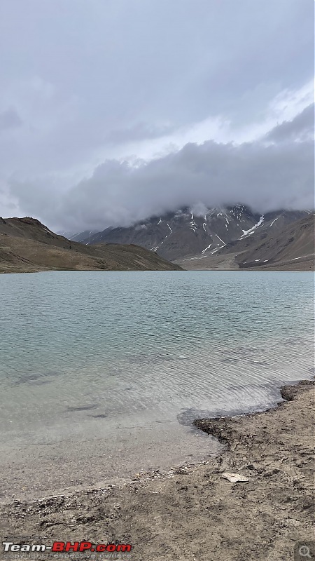
But we promised ourselves that we won’t stay at the lake for more than an hour, with that in mind we took the road towards Chandrataal, the road is narrow only one car can pass at one time and the same water was flowing all over the road, we saw some camps just before the lake parking but they seemed to be closed probably because the road to Chandrataal was not officially opened then, We reached the lake parking at 3 Pm, lake is 10/15 minutes trek away from the parking and there’s no ticket for the lake or the parking.
As we were approaching the lake we saw a small frozen water body, and then came the first glimpse of Chandrataal, that first glimpse from the trek made everything worth it, the off roading the water crossings everything felt so so worth it. It’s a pristine blue lake with snowclad mountains all around it and the chilly wind blast such was the experience of Chandrataal, we spent 30-40 Minutes at the lake mesmerized by it’s beauty, and then headed back to the intersection which would make us join the road towards Koksar again.

After coming back from Chandrataal
Check out BHPian comments for more insights and information.
- Tags:
- Indian
- Member Content
- Travelogue
- Honda
- Amaze
Find Car News
Just News
.jpg)


About Us


Buy & Sell
USED CARS