News
A 5,500 km road-trip from Shillong to Nepal in my Renault Duster
We consumed 350 lit diesel worth approximately Rs 30,000 over a distance of 5500km. I describe our experience during each leg of our journey.
BHPian abyb recently shared this with other enthusiasts.
This is my first post on Team Bhp. Though I have been a regular reader of the portal, I was only recently motivated to formally join and post my experiences, following my experiences during my recent trip from Shillong to Nepal, thereon to Delhi and back to Shillong. Reliable first-hand experiences and route suggestions were not easy to come by. The ones that were there online were either old or sketchy. We learnt on the way. A part of the issue was the region where I live- North East India. Not many route advisories are available online from these parts of the country. I describe my experiences regarding the route and the actual driving (route, road conditions, permits and legal conditions) conditions prevalent at the time of writing the post to guide prospective travellers on this route. This is not a description of our activities or hotel stays. Road conditions and legal requirements are rapidly changing in India as well as in Nepal and the same should be accounted for by any traveller.
Our vehicle was Renault Duster AWD 2017. Me and my wife had planned for a long-pending road trip to Nepal and Delhi from our home in Shillong. Our route was also planned depending upon availability of starred/high end hotels. The route we covered over a period of the next one month was:
Shillong- Guwahati-Siliguri-Kathmandu-Pokhara-Lumbini- Lucknow- Delhi- Gorakhpur-Patna- Siliguri- Kokrajhar- Shillong.
We consumed 350 lit diesel worth approximately Rs 30,000 over a distance of 5500km. I describe our experience during each leg of our journey.
Shillong- Guwahati:
We set out from Shillong on 29th Nov 2023 evening for Guwahati. Time may be consumed while leaving Shillong due to the abysmal traffic situation in the city. We took our usual route out of Shillong, via North Eastern Hill University- Mawlai Bypass- GS Road route to reach the main highway (GS Road). Once we crossed Umiam lake and reached NH 6, it was a smooth four-laned expressway till Byrnihat, beyond which lies Khanapara and Guwahati. It’s a pleasureable drive with plenty of food options and fuel stations. Refueling in Meghalaya (Byrnihat/ Jorabat/ Khanapara), just before entering Assam is recommended. This was the cheapest fuel we got on our entire trip (Rs 85/lit). Contrary to popular perception, Nepal was the most expensive at ~Rs 100 for diesel in INR. We did this short segment because we have a home in Guwahati too. Else, Shillong to Siliguri is doable in one day. It might take about 12 hours. Shillong to Siliguri is a trip we undertake very often, and hence the experience described is based on multiple trips over the last 10 years.

Guwahati- Siliguri:
Route taken: Guwahati- Rangia- Barpeta- Srirampur/ Barobisha- Madarihat- Binnaguri- Mal Bazar- Sevoke Bridge- Siliguri (NH 27)
We started at 6:30am. Though the journey takes about 10 hours, an early start is recommended in view of the ongoing road widening- flyover/ underpass construction works on the stretch up to Jalukbari, which when crowded during school/ office hours, might delay you by a long time. From Jalukbari, we took the NH 27 via the Dooars. This route has variable road conditions up to Srirampur on the Assam-WB border. Though it is a four-laned road and the surface is largely good, road widening/ flyover construction work is going on at multiple places and bottleneck areas vary. Flyover construction is taking place upto Bongaigaon presently. Eating joints are aplenty on the way up to Bongaigaon. It is recommended to have a meal before Bongaigaon since there won’t be too many decent food joints till Madarihat in North Bengal. Beyond the Alipurduar intersection, the route is a well metalled double-laned road since this route passes through multiple wildlife sanctuaries of the Dooars. It’s a pleasurable drive through lush greenery.
The alternative route that may be taken is the Guwahati- Azara- Dudhnoi- Goalpara route, which merges with NH 27 before Bongaigaon. Though it is longer and slower but it is a well-metalled route, there are not many heavy vehicles here. When traveling at night, it is better to proceed from Hashimara towards Siliguri via Dhupguri- Jalpaiguri route despite heavy vehicle traffic because the route we took is deserted at night and passes though wildlife sanctuaries. We reached Siliguri comfortably by 5pm.
Siliguri- Kakarvitta- Kathmandu:
Our route plan to Kathmandu from Siliguri was the most uncertain. Each person we asked for guidance had a different route suggestion. We were joined by our friend, Siddharth from Kalimpong for our journey. We stayed for 3 nights in Siliguri, and departed for Kakarvitta at 6am on 2nd Dec. On crossing the Panitanki border, around 30 min from Siliguri, we were directed by Nepal police towards the Bhansar (custom) office for obtaining the vehicle permit. The Bhansar office was open when we reached there at around 7am. Here the following points must be taken care of:
The only documents you would need for entry with vehicle are ORIGINAL RC (photocopies just won’t be accepted, though they might retain a photocopy with them- carry some photocopies of all documents) and an Indian ID card. We took the permit for 15 days for 9000 NPR or 6000 INR. Indian rupees were accepted here. The time required for this formality is half an hour. There was no harassment at this point. No bribes are asked for nor are needed to be paid.
- Green number plate mentioned in many posts is not currently required. No further documentation is required till Kathmandu.
- The receipt and Bhansar document in original must be retained throughout the stay in Nepal to be handed over to the border check post on exit.
- Digilocker is not considered a valid document in Nepal.
- Legal requirement for another permit for each district @Rs 500 per day exists, but is not rigorously implemented. We had to take that permit only while entering Pokhara.
- It is illegal in Nepal to be in possession of INR 200 and above denomination currency notes. The same may be seized. Kakarvitta is the only town where Rs 200 and Rs 500 notes are accepted. Beyond this, only Rs 100 and below are valid. INR may be exchanged for NPR in Kakarvitta.
- Even damaged NPR currency notes are acceptable.
- Google maps are not reliable in Nepal. It is advisable to keep asking the locals/ plan route in advance. People can understand English and Hindi to a reasonable extent.
- Driving after consumption of alcohol is a crime in Nepal and police are strict in Kathmandu and Pokhara about this law. We did not touch our car after having any amount of alcohol. Vehicle may be seized and the owners will have to appear in court to retrieve it.
- It is important to remember that Nepal is a separate country with its own laws. Nepalese take great offence at any hint otherwise.
We had our breakfast in Kakarvitta and departed for Kathmandu. We took the following route, skipping the one suggested by Google maps:
Kakkarvitta- Itahari- Chhatara- Upper Sapta Koshi Bridge- Ghaighat- Katari- Bhiman- Bardibas- Sindhuli- Dhulikhel- Banepa- Kathmandu.

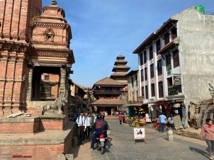
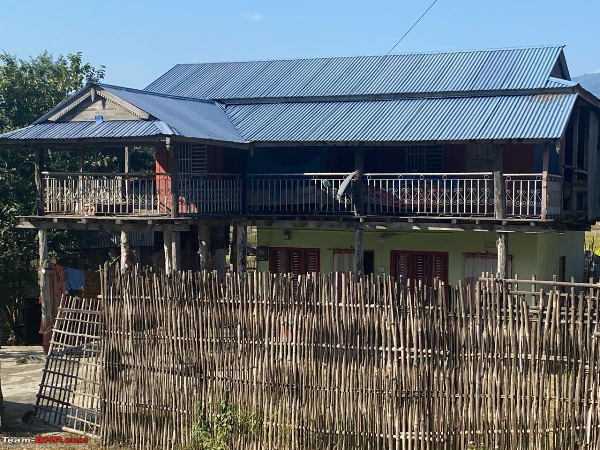
Any other route might lead to roads that are under construction or in a dilapidated condition. Roads are constantly being upgraded in Nepal and preferred routes may change quickly. We identified this route after a lot of research and also suggestions by our acquaintances in Nepal and frequent Indian travellers to Nepal among our friend circle. This was a new route that has been opened up and was strongly recommended and rightly so. The roads are by and large good and well paved, though only double laned (the Nepalese call them four laned though). The right turn at Itahari for Chhatara is inconspicuous and can be easily missed. Ask locals for the route to Chatara/ Saptakoshi Bridge and Kathmandu, or look for Saptakoshi bridge on Google maps. The hill road starts beyond Itahari. The Nepal countryside is a sight for sore eyes- fields and greenery all the way, with quaint villages and houses made in traditional style, corn left to dry in the traditional way. The climb is steep beyond Sindhuli, before the road descends into the Kathmandu valley. The journey from Kakarvitta took 12 hours and we reached Kathmandu only at 8:30 pm. In hindsight we took more halts than we should have, thereby slowing us down substantially. Beware of the trucks and buses. They can be reckless. There are plenty of eating joints on the way. Refuelling is suggested before leaving Itahari. Fuel quality might be an issue in Nepal and hence it is better to refuel only in major towns. Bhat- Bhateni in Itahari is a good place to eat and shop before proceeding ahead.
For those not able to make the journey in one day, it is advisable to break the journey in Hetauda. Hetauda is not on the route that I have described above, but is the only place that offers decent hotels. It is also important to bear in mind that the last 20 km from Banepa to Kathmandu are notorious for massive jams, that can set you back by hours.


Kathmandu-Pokhara:
Route taken: Kathmandu- Naubise- Mugling- Byas-Pokhara.
There is not much confusion about the route on this segment. We departed for Pokhara on 8th Dec. Though only a 200 km journey, the roads on this section were the worst we experienced during our journey. The drive can take anything between 8-10 hours. An early start is recommended to reach Pokhara before dark. You wouldn’t want to negotiate such roads in the dark. Roads are in a somewhat better condition up to Mugling, which is approximately half-way. Thereafter, it is a major road construction zone and almost no blacktopped road existed till we entered the Pokhara valley. We were stopped at a traffic checkpoint and asked to take a permit for Pokhara district at the local district transport office. We took a permit for 3 days @Rs 500 NPR/ day. This document was never asked for again. Lunch at Mugling is strongly recommended before one starts the dilapidated stretch of the highway. There is a diversion to Gorkha on this route, for those interested in a visit. During our trip, the road conditions from Kathmandu to Pokhara were too bad for us to think of a detour.
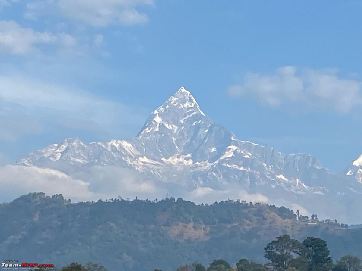
Last i heard, blacktopping of Mugling- Pokara road is well underway. We entered the Pokhara valley at 4pm. Thereafter, till our hotel on the lakeside, progress was slow due to traffic on a double laned road. Pokhara does not have many branded hotels. Only local hotels are available. As per our experience, hotels in Nepal offer value for money. You get what you pay for, not less.

Pokhara-Lumbini:
Route taken: Pokhara- Waling- Palpa- Butwal- Lumbini.
Google maps may not be reliable to decide the route on this segment. This route is entirely a hill road up to Butwal. Road conditions are satisfactory except in patches. This is a narrow road unlike Kakarvitta to Kathmandu or Kathmandu to Pokhara.
We left Pokhara at 9 am on 12th Dec and reached Lumbini by 3 pm. There are plenty of meal options on the way. Lumbini is in the plains and only 10 km away from the Indian border in Uttar Pradesh. Butwal is the major town here and most hotel options are also in Butwal. Lumbini is only a sparsely populated pilgrimage town. Hotel options are limited. We stayed in Buddha Maya Garden belonging to Kathmandu Guest House group and was a decent, comfortable option. Exploring Maya Devi Temple complex in Lumbini, unless you are on a pilgrimage, takes just a few hours.
Lumbini- Lucknow:
Route taken: Lumbini- Kakrahwa- Basti- Ayodhya- Lucknow.
We departed for Lucknow at noon on 13th Dec after a trip to the Maya Devi Temple. Though the major border crossing is at Sunauli, which is on the route to Gorakhpur, we exited Nepal at Kakrahawa, around 10 km from Lumbini. Crossing over at Sunauli meant taking a detour of 60 -70 km. This is a small border crossing and hence is not on any main highway. Google maps is not recommended when deciding the border crossing from Lumbini. There are multiple border crossings between Nepal and India. It is advisable to enquire before choosing a border crossing, since some border crossings are only for cargo.
We deposited the Bhansar documents with receipt with the Nepal Bhansar check post at the border on request. India’s SSB personnel wanted to check our car, but then backed out seeing the amount of luggage we were carrying. Our Indian ID card, vehicle documents and driving licence were checked by the SSB before crossing over. Roads up to NH 27 at Basti though good, are narrow and congested. NH 27 leading to Lucknow, though well metalled and 4 laned, is fairly congested. Major construction activity was going on around Ayodhya and progress was slow. The place was dusty too. We reached Lucknow at 8pm.
Lucknow- Delhi:
Route taken- Lucknow- Agra (Taj Expressway)- Delhi (Yamuna Expressway, Greater NOIDA- NOIDA Expressway, DND flyway)
This was the best road and the only true access-controlled expressway we encountered on our journey. 500 odd km were covered in 7 hours on 14th Dec. There are only two pit stops on the Lucknow Agra stretch, all 100 km apart, on the 300 km highway. Agra- Greater NOIDA expressway has plenty of halts for fuel as well as meals. The truth about great access controlled expressways is that they are singularly characterless. You are transported from one city to another without having any interaction with the villages, towns and the environment or the countryside around. For meals or fuel, characterless, deserted mall-like structures with branded food options make the journey unremarkable. Too bland for my tastes.
Delhi- Gorakhpur:
Route taken: Delhi-Lucknow- Ayodhya- Gorakhpur
We left for Gorakhpur from Delhi on 27th Dec 2023. This was a very long and stressful drive, of around 800km. Ayodhya would have been the most appropriate for an overnight halt, but we decided to go for Gorakhpur, given the dusty conditions in Ayodhya we saw during our onward journey. We started at 6:30 am. Due to the exceptionally dense fog in Delhi, our progress was painfully slow till 11 am. Negotiating through Lucknow to reach Purvanchal expressway was painful and time-consuming. Thereafter, we took the Purvanchal expressway upto Sultanpur, from where we took the Ayodhya highway. This was as per the Google maps recommendation, which keeps showing different routes as per traffic conditions. We reached Ayodhya in about 10 hours. Thereafter, progress was slow, due to traffic conditions on NH 27. We reached Gorakhpur at 8pm. NH 27 and the Sultanpur- Ayodhya highways were both well paved 4 laned highways.
Gorakhpur- Patna:
Route taken: Gorakhpur- Kushinagar- Gopalganj- Mohammadpur- Patna
This segment was a result of a miscalculation. Our original plan was to head straight to Siliguri from Gorakhpur. That’s what we were told, and also read on various online portals, was comfortably doable (some travellogues from as far back as 2013 too suggest this itinerary). However, on checking Google maps, the journey was taking 13 hours for a distance of 650km. And given our tiredness from the previous day’s drive, we were in no mood for it. We expected the highway to be nowhere near Delhi- Lucknow stretch. So we decided to proceed to Patna. Patna was a detour of about 2 hours from NH 27, and the only city on or close to our planned route to have good hotel we could rely on, the Lemon Tree. Muzaffarpur, Darbhanga or Araria on our planned route had no such property. In hindsight, probably heading to Varanasi from Delhi the previous day might have been a better option if we were to go to Patna. But that’s in hindsight.
We departed from Gorakhpur on 28th Dec after a quick visit to the Gorakhnath Temple, at 11am and crossed into Bihar at Gopalganj while following NH 27. It is important to mention here that Bihar being a dry state, the vehicle might be checked on entering the state. The next miscalculation possibly was the reliance on Google maps to reach Patna. We were navigated through the village roads to reach Patna. Though the roads were in good shape, they were single or double laned beyond Mohammadpur, passing through the Bihar countryside and mofussil towns. Probably going via Muzzafarpur might have been more appropriate. However, we covered the distance in 6 hours after a late start with no halts for meals or tea because there was no decent place for the same.
Patna- Siliguri:
Route taken: Patna-Muzzafarpur-Darbhanga- Forbesganj- Araria- Purnia- Dalkhola- Kishanganj- Siliguri
We started from Patna at 7:30 am on the 29th Dec. This is another route where one must avoid following the route suggested by Google maps. The route mentioned in this post is a good four laned highway all through to Siliguri, with no diversions from NH 27. This day was a pleasurable drive all the way, NH 27 being in good shape, comfortably enabling speeds beyond 90kmph. Eating joints were a rarity for finicky people like us. We were in Bagdogra by 5pm. Entering Siliguri was a pain due traffic jams beyond Bagdogra. Key take aways: Unless you are a "cool guy with a swagger", do not attempt Gorakhpur- Siliguri in one day. Crossing a state as big as Bihar in a single day is not easy. Stick to NH 27 all the way from Ayodhya to Siliguri, irrespective of what google maps suggests.
Siliguri- Shillong:
Route taken- the same as mentioned while going from Guwahati to Siliguri. Route recommendation remains the same as during the onward journey.
Read BHPian comments for more insights and information.
Find Car News
Just News

.jpg)


About Us


Buy & Sell
USED CARS