News
Exploring Iceland in a Land Cruiser: Travelogue of our 10-day long trip


Embarking on an independent self-driven road trip is the best way to fully immerse oneself in the captivating beauty of this island country.
BHPian brownianmotion recently shared this with other enthusiasts.
Prologue
Iceland, the land of fire and ice, adorned with volcanoes, ethereal northern lights, embraced by majestic glaciers, and framed by the silhouettes of ice-capped mountains and countless waterfalls, had long held a cherished place in our imagination. A serendipitous conversation with a friend regarding the harrowing tale of my 2010 ordeal of being stranded in Heathrow due to the Iceland volcano eruption laid the foundation for our trip to Iceland.

With Landscruiser en-route Borgarness on Ring Road

Northern Lights
Iceland unveils its true essence in its profound isolation, in that dirt road going nowhere, those winding hiking trails, in its horse farms by the roadside, in its tiny villages and gas stations, and in its unending panoramas of volcanoes, mountains, lave fields, glaciers, coastlines and waterfalls and most importantly in its capricious weather conditions and unforgiving yet glorious terrain. So, no wonder that embarking on an independent self-driven road trip is the best way to fully immerse oneself in the captivating beauty of this island country. And to go around the country, the best way is to travel via Ring Road or R1 which runs in a circle around the entire country.
Planning
Important Information about Iceland:
- Population : 337 K
- Capital : Reykjavik
- Currency : ISK - but EUR is very common.
- Area 103 K sq km
- Emergency Number : 112
- Calling code +354
- Plug type : C + F on 230 V
- Language : Everyone understands and speaks good English
- Almost every Icelandic last name ends in -dottir (female) or -son (male). Kirkja is church, 'foss' is waterfall, 'jokull' is glacier, 'fjall' is mountain.
- TIPS is not in vogue in Iceland – no one expects you to tip
Important websites:
- Road conditions: www.road.is
- Local weather: www.road.is
- Iceland transport and Drone controller https://www.icetra.is
- Safe Travel: www.Safetravel.is
- Tunnel toll www.tunnel.is
- Car crash app http://www.carcrash.is
Grocery and food
- Krónan Supermarket and Bonus are 2 major ones. Bónus Iceland typically opens at 10 a.m. and closes between 6 and 8 p.m. Kronan is more expensive than Bonus. Larger Kronan stores may have a pharmacy and café as well
- Websites: https://kronan.is/grocery-store and https://bonus.is/english/
- Others are Costco, 10/11, Nettó, Samkaup, Kjörbúðin + Kjarval, Hagkaup
- Water : No need to buy bottled water! It's very costly. Use your reusable water bottle. In Iceland you can drink the water from the tap - it is pure.
- Skyr (Icelanding yoghurt) and Pylsur (Hot Dog) are the most popular food and your guide to survival in costly Iceland. Real foodies can try local specialities like Reindeer meat and Hákarl (fermented shark). Also, Licorice (liquor-filled chocolates) are absolute favourites.
Timing
This year, the Puja holidays were starting much late in October which opened up a great opportunity for a 10-day trip across Iceland. In October, you get a good amount of daylight from 8AM to 6PM for exploring Iceland’s stunning landscape and at the same time, you have a high chance of witnessing the elusive northern lights. Also, October being a ‘shoulder’ season between summer and winter, the crowd is less and you have potentially more budget-friendly rates compared to the peak summer season. However, the biggest drawback is that October is the windiest and the wettest month often accompanied by occasional blizzard or storm, which may lead to temporary road closures or travel restrictions.
Clothing
Prepare for cold, wind and rain. Good windproof jackets as well as waterproof rain jackets are absolutely essential. Also, as we would learn, in winter or shoulder season one must rent or carry microspikes as in many places it gets extremely slippery.
Itinerary (initially planned)
As this is almost winter, so tourists won’t be allowed to venture into the Highlands in self-driven vehicles. So the best option is to go around Ring Road (R1) and take detours to explore different parts. At the same time, we have only 10 days which is much less to explore Iceland. Ideally, it is better to choose one or two areas and explore those in this time instead of attempting the whole of Iceland. But again Iceland is not a place where you can come often. So we tried to balance our itinerary as following and also planned for some adventure activities:-
- Day 0 - Start from Kolkata via Doha, Copenhagen
- Day 1- Reach Iceland. Take a car rental and drive to Hotel Ion Adventure (away from Reykjavik so as to maximise the chance of the Northern Lights)
- Day 2- Golden Circle and move to Snaefellsnes
- Day 3- Snaefellsnes Peninsula
- Day 4- Snaefellsnes to Mývatn in Northern Iceland
- Day 5- Mývatn to Easter Fjords
- Day 6- Egilsstaðir to Jökulsárlón (zodiac ride)
- Day 7- Jökulsárlón (snowmobil, glacier caves)
- Day 8- Jökulsárlón to Hella
- Day 9 - Hella (Landmanalagaur Super Jeep Tour)
- Day 10- Hella to Keflavik via Skógafoss, Seljalandsfoss and depart for Kolkata
But Iceland is not a regular road trip, so you really cannot plan everything to perfection. As we would learn over the next 10 days, that, in spite of planning every detail of our itinerary, there was no way we could anticipate the storm, the rain or the snow which from time to time would force us to change our plan. But believe it or not, we would not trade this uncertainty or unpredictability for anything else. It is these diabolical uncertainties which add to the fun of driving around this amazing island country located between the North Atlantic and the Arctic Ocean.
Adventure Activities Planned
- Landmannalaugar Super Jeep Day Tour (in Highlands of Iceland) - South Coast Adventure ( https://www.southadventure.is )
- Glacier Ice Cave hike in Vatnajökull glacier - Local Guide of Vatnajökull (localguide.is)
- Snowmobile ride on Vatnajökull Glacier - www.glacierjourney.is OR adventures.is
- Zodiac boat ride in Jökulsárlón - Glacier lagoon tours (www.jokulsarlon.is)
However, given this is a shoulder season bordering winter, there is a high chance that any or multiple of these can get cancelled due to weather.
Flights
We booked our return tickets to Keflavik on Qatar Airways. However, in hindsight, Finnair flight from Delhi via Helsinki is a better option as Qatar Airways reaches very late in Keflavik. Remember Iceland is 5:30 hrs behind India time. Ideally, if you arrive late, you should stay near the Airport and take rest before embarking on your journey the next day. Otherwise it will be tiring as we learnt from our experience.
Visa
We need to have a Schengen visa for Iceland. It’s usually issued for a month with a single entry if you are only going to Iceland. Though Schengen visa is easy, it's best to make sure appointments can be obtained in due time and all the right forms are filled up (Iceland authority changes their forms frequently and one should always check for the latest one).
Clockwise or Anti-clockwise
Most people in Iceland prefer to travel from east to west in an anti-clockwise direction. If you are going in summer or winter it does not matter which way you take. But if you are travelling in shoulder seasons like October and on a tight schedule then you need to decide whether you want to optimise your day light time Or mitigate risks of bad weather - accordingly, you may choose the direction. If you travel east to west anti-clockwise, then you have early sunrise in the east and late sunset in the west giving you maximum daylight hours - a good half-an-hour gain. However, if you travel from west to east clockwise, you will go through the Northern part earlier where the weather is supposed to deteriorate rapidly as you move closer to winter from shoulder season. We decided to do a clockwise round tour.
Accommodation
Initially, we thought about hiring a camper van and staying there as it would give us more flexibility and prevent us from the hassles of frequent check-in and check-out. But later on realising that October is wet, windy and cold, we decided to discard the idea and started looking for accommodation. Soon, we found out why Iceland is considered as one of the costliest countries to visit - the prices of Airbnb and hotels are way higher than any place we have ever visited. Probably we should have started booking 6 months in advance or more.
Car Rental
After finalising the itinerary, it was time to rent a car. Generally, I do not prefer a self-drive excursion without my own vehicle - but here I had hardly any choice. We rented our car from ‘Blue Car Rental’ which has a good rating and whose office is located just across the car parking lot outside Keflavik airport, so it is effectively a 6-7 minute walk from the airport. This was very important for us as we were scheduled to land at Keflavik airport at 6 PM. Now the shuttle to car companies usually runs upto 6 PM only. So the rental company better be walkable. We decided to rent a Jeep Compass Trailhawk 4x4, the same car model which we have. However, Trailhawk was not available, so we settled for a regular Compass 4x4.
F-roads of Iceland
F-roads (short form of fjallið roads or mountain roads) are generally closed by September end (https://epiciceland.net/list-f-roads-iceland/). Unless you are driving on F-roads or icy roads in Icelandic winter, you do not need a 4x4. Since we were going in October, we opted for a 4x4 envisaging that early snow can create problems in accessing some areas.
Parking
There are both paid and free parking in Iceland in various tourist attraction locations. There are apps where you can pay as well as physical kiosks. However, the best part in Iceland is that while driving down the country, from time to time you will come across lovely rest area parking by the roadside which has unparalleled scenic beauty all around. Iceland's wind is notorious. In fact, after Antarctica, Iceland is the most windy country. While parking, unless you park against the wind, there might be situations where your car door can be blown away during ingress or egress. So be careful as no insurance will cover such damage.
Network and Wifi
There is an optional wi-fi connection device offered by rental car companies. You can take a wi-fi device at the airport as well. We opted for the wi-fi connection provided by the rental company because:-
- We are arriving late and getting the device from the airport would be time-consuming. Otherwise you can also get the device from 10/11 stores in the airport. You can pre-book a SIM card on https://iceland.trawire.com from 10/11 store in Keflavik airport. You can return it to the same place while returning or choose to send it to a mailbox through a pre-paid envelope.
- They offer SIMINN network which is the best network in Iceland in terms of voice and data connectivity
- This comes as a standalone device which can be carried to the hotel or guest house.
Car Insurance
Understanding car insurance in Iceland can be a subject by itself. Most of the insurances come bundled with car rental, however, we also opted for sand and ash protection, liability waiver, roadside assistance waiver etc.
Driving in Iceland
Iceland has left-hand drive vehicles with traffic flow on the right side - similar to the USA. You do not need an International driving permit to drive in Iceland. If your driving license is in English, it is good enough. But driving rules are very strict here, especially speed limits are quite stringent and penalties are very high, running into hundreds of dollars, so it is recommended to be aware of the driving rules and understand the road signs before embarking on a self-drive tour in a rented car. Most of the roads are paved, though from time to time we encountered many gravel roads and a few dirt roads. Also, there is no concept of 'off-road' or greenlanding. In fact they are strictly prohibited. Weather plays a very important role in this strangely beautiful country. So every day before the start of the trip, you need to check the road conditions in road.is app to confirm if your planned route is open or you need to take a detour.
NOTE: Fuel price is very costly. Iceland is only second to Hong Kong with respect to gas prices.
- Do not stop on the road to enjoy a view unless there is an emergency. Park only in the designated roadside area if you need to stop
- Always headlights on - not only DRL
- Two lane Roundabouts : Inside lane has the right of way and hence it's best to use only the outer lane if taking the first exit. Watch for lower speed limits once you see the roundabout sign. If you are taking the first exit, use the right (OUTER) lane. Otherwise, better to take the left (INSIDE) lane.
- Speed limits : Paved highways : 90 kmph, Gravel road : 80 kmph, City limits : 50 kmph
- When you reach city limit or exit city limit the speed decreases or increases in 3 steps - 90-70-50 or 50-70-90 . Look out for signs of City limit ending or starting
- Narrow bridges : You will see signs of narrow bridges. Once you see the sign, you need to see if another vehicle has already entering the bridge. If so, then you need to stop there till the vehicle crosses over.
- Watch out for signs of paved road turning into a gravel road
- Few ad-hoc materials which I collected to read about road signs and rules in Iceland - Download Iceland Driving.pdf
14th October - and the journey begins
We came back from the office on 13th October evening, gave our packing a final touch and started for the airport. All anticipation and planning was about to culminate in the next 11 days.
Kolkata to Keflavik, Iceland
Flight QR541 started from Kolkata at 03:50 and reached Doha at 06:30 AM. Flight QR6126 from Doha started at 08:05 AM and reached Copenhagen at 13:50. There was a 3 hrs layover at Copenhagen. We had our lunch at an airport cafe and rested a bit. As Copenhagen was our first point of entry into Schengen zone, we had to do immigration here. Though we were amused to find that there was nobody at the immigration counter - we had to call a person from his desk and ask him to do it. The last leg from Copenhagen started at 16:40 in Scandinavian airline flight which does not even offer a glass of water free. The approach to Keflavik over snow-capped mountains and the final descent over the ocean was very scenic. Finally, we landed in Keflavik international airport on Saturday 14th October at 18:25.

Iceland from above

Touching down Iceland
The last leg of our journey was quite tiring. Thankfully we did not need to do any immigration as it was already done in Denmark.
At the airport
Today we need to drive about 84 km to our hotel which is located near Thingvellir National Park. We chose the place, because it is much away from the brightly lit city of Reykjavik, and this being close to New moon day, an Aurora will look stunning. But given today’s weather, that’s just a pipe dream. As it’s already late (in Iceland terms), by the time we reach the hotel, kitchen would be closed. Also the supermarkets around Reykjavik, like Krónan and Bonus all close by 8 PM.
So, we picked up some small food items, drinks from the grocery at the airport and had an early dinner with a famous Icelandic hotdog ( or Pilsur as they call it) in Bæarins Beztu Pylsur which is an old and famous chain for Icelandic hotdogs located within 10/11 supermarket in the airport. Hotdogs costing around 600 ISK , along with fried onion and honey mustard tasted awesome. As we will learn in the next 10 days these hot dogs are not only the lifeline for people on a shoestring budget but they save a lot of time and taste awesome. Otherwise, as we will discover, everything in Iceland is way too costly. Since all single-use plastic is banned, we need to pay for the grocery bag as well.

At Keflavik Airport
The weather
As soon as we landed in Iceland, we started getting a taste of unpredictable yet fascinating Icelandic weather, when we got a notification that our snowmobile tour has been cancelled following an early termination of the season due to bad weather in South Iceland. Coming out of the airport we can feel the vicissitudes of Icelandic weather as we see different parts covered with a layer of snow and a light drizzle.
Car pick up
It took us about an hour to pick up our luggage, clear customs and have our dinner. When we started walking towards Blue Car Rental office, it was 7-20 PM. It was quite cold outside. We exited through the Departure gate ( not arrival gate) and walked across the parking lot towards Blue Car Rental from where we rented our Jeep Compass. Usually, you can take an airport shuttle which drops you to different car rental companies. However, those shuttles run up to 6 PM. So we have to walk. It’s a short walk. But in days of bad weather like this, this 5 minutes walk with luggage seems long and arduous.
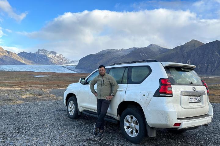
The Steed
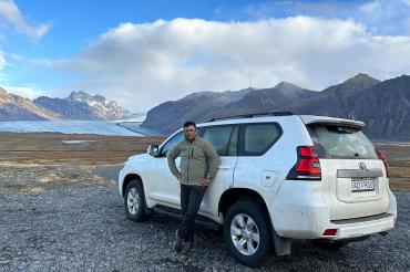
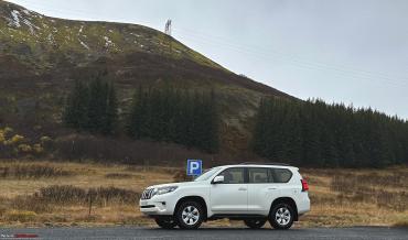
Once we reach the rental company, we found that the car that was given to us was not the one we booked. We had booked a Jeep Compass 4x4, but here is a giant Toyota Landcruiser 4x4 waiting for us. As we did online checkin and prepayment in Copenhagen itself and got the code in mail, we picked up the car key from the locker. Now, like in all rental companies Blue Car also have a policy that if the chosen vehicle is not available at that point they will provide a similar or better vehicle. So they upgraded me to a Toyota Landcruiser. Alas, little did they know that I am not a big Toyota fan.
Seeing that I was not quite impressed with the upgrade, the person at the rental company wondered why I am not very delighted with the upgrade. Of course, this car comes with lots of bells and whistles and a 4x4 with Transfer case unlike my JCT back home. Though the pickup process was very easy, we found there was a warning sign on the control panel saying “Pre-Collision System Malfunction”. We asked the executive who had handed over the car to us if we should worry about it, but he was not able to offer any help, though he assured us that it was not a problem as this impacts ADAS. Anyway, I was never going to use ADAS and so did not give it a damn. The white Landcruiser looks gargantuan in size with a high driver view. We checked the other controls, fuel type (normal Diesel), fuel level, AdBlue levels, tyre pressure, lights, wiper, battery indicator and the wi-fi device. We took some record photos and loaded our suitcases and bags in the car (nothing to complain about the boot space - it's HUGE) and rolled out of the parking lot.

Getting onto left side after a long time
Road from Keflavik to Reykjavik

Driving route from Airport to Hotel
We came out of the Blue Car Rental office at 8:15 PM and turned onto Route 41. The GPS was working fine and the heating system was excellent. It was still drizzling lightly and there were very few cars on the road. Outside temperature was 4 deg C. Our hotel ‘Ion Adventure’ was 84 km from Keflavik airport. It was 33 km away from Reykjavik. Reykjavik is the capital city of Iceland with a population of 130000 meaning every 1 of 3 persons in Iceland lives in Reykjavik.

First drive in Iceland

On the highway
Reykjavik to Hotel Ion Adventure
We continued on Route 41 for about 50 km. As we moved out of the city, speed limit increased to 90 kmph, which is the highest limit in Iceland. In the city it varies from 30 to 50 kmph depending on the density of the locality. There were no street lamps outside the city limits, which is apt, as you need perfect darkness for northern lights. The road markers were glistening in the dark From Reykjavik we took road no.36 and turned right onto road no.360. This route remains open throughout the year, unlike a shorter route via road no.435 (suggested by GPS), which remains closed from October to April.

Light snow-laden road
The last few kilometres, especially the last mile was covered in ice and very slippery. Thankfully, we had no problems as the land cruiser was a 4x4. The wind was howling outside. As we reached the parking lot of Hotel Ion Adventure, we find it a challenge even to walk few meters to the hotel as it was too slippery. We were glad to be inside the hotel. After having champagne as a welcome drink, we registered ourselves for an Aurora wake up call and went to sleep knowing quite well that it's impossible to witness Aurora today given the weather conditions.
15th October - Golden Circle to Snæfellsnes

Route through Golden Circle upto Snaefellsness
Waking up to a snowy landscape
It snowed throughout the night. As expected, there was no aurora even though we did set up our camera and remained awake till midnight waiting for that elusive light and then fell asleep. We woke up a little late on 15th due to jet lag.

Snowscape from our hotel
As we wake up, to our amazement, a glimpse of snow-covered surroundings through the window panes revealed like a fairyland. We had an elaborate breakfast in the beautiful Silfra restaurant watching the snow peaks in the distance.
After breakfast, I tried to look into the car manual to get used to the controls (it’s always difficult for me to adapt to new controls). Last night, I was not able to drive in cruise control and thought I was doing something wrong. When I called up the rental company, they told because of this ADAS issue, Adaptive Cruise control (or even standard cruise control) will not work. They told they can send us a replacement or I can bring it to their office in Reykjavik or Snaefellsnes. I gave them a strong message that this is not acceptable but decided not to make a fuss over it as, to be very frank, cruise control is not worth of losing your time on.
Golden Circle
After clearing the car from a bit of snow, we set out on the road at 11 AM for our tour of Golden Circle. As we were running late, we decided to go straight to Iceland’s most famous waterfall in the Golden Circle - Gullfoss - which is 82km from here. Golden circle is a route from Reykjavik to Thingvellir national park, Geysir geothermal area, Gullfoss waterfall and back to Reykjavík. This is a common route taken by most tourists who spend 2-3 days in Iceland and want to get a quick glimpse of the country.

Landcruiser en-route golden circle
We checked out from Ion Adventure Hotel and drove from R360 to R36. Then we kept driving through Thingvellier National Park. There is a light drizzle and the roads have a thin snow cover. One important point - in Iceland, it's a rule that you need to drive with your headlights on always - only DRL won't suffice. We were driving through volcanic landscape and would often get the faint smell of H2S. Even the running water from tap in the hotel smelled of H2S. Our hotel was located in Mt Hengill geothermal area. Here, like in many parts of Iceland, geothermal water (or rather steam) is used to warm up cold water for domestic use. In energy stations, the small quantity of steam containing acid gases is mixed with the water to eliminate dissolved oxygen and to lower pH in the water to prevent precipitation. That’s why the water system near geo thermal power stations often has a a faint smell of H2S. It was a little difficult to adjust to the smell at first as we drank the same water but soon we got used to it. In Iceland, you can drink water from the tap. It comes straight from the glacier. You don’t need to buy water at all. In fact bottled water is extremely costly.
Thingvellir National Park

Thingvellir National Park

At lake Þingvallavatn
Iceland is split between Eurasian and North American tectonic plates. As a result of this tectonic drift, deep rift valley has formed in the area. Every year 2 plates drift away 2.5 cm in the opposite direction slowly tearing apart Iceland and increasing its size. Thingvellir National Park area is part of the Atlantic Ocean ridge, a part of the North American tectonic plate. Nearby you have snorkelling facility in Silfa fissure where you can snorkel between 2 plates if you don’t mind getting numb in cold. Within 10 minutes of our drive, we were compelled to stop by the captivating view of serene Lake Þingvallavatn. There is a parking area just by the road side where we parked our car. In the coming days, we will find out that throughout Iceland, such parking areas are located in the most obscure yet most scenic locations where that one can relax and enjoy the countryside. We enjoyed the view and walked by the lakeside. There was also a Dacia Duster parked. In fact, Landcruiser, Dacia Duster and Jeep are very popular here. In Iceland, you just cannot stop on the road - especially on a 2 lane road. That’s why it’s so difficult to do a ‘Follow me’ drone shot on your car.

Stopping at a rest area surrounded by snowscape
We continued our drive through the drizzle and moss-covered volcanic landscape. Now there is no snow on the road. Soon we reached the famous one-lane bridge. Before every one-lane bridge, the speed limit slows down to 70 and then 50. You need to watch if somebody is coming from other side or not and then proceed. By the way, this entire road what we have driven so far is a 2-lane road - not 4 lane. As we drive along, the view of Langjökull glacier opened up all on a sudden, piercing the overcast sky. But the sight was short lived and soon covered with haze. Though the road surface is good, in few points there are small craters reminding me of EM Bypass in rainy season or erstwhile NH34. After some more time we encountered a very well maintained gravel road. In all gravel roads, max speed limit is 80.

Aerial view of snowy landscape with Langjökull
We reached a T junction from where we took right onto R365 towards the town of Laugarvatn. After some time, again some light snow started appearing on the road. We spotted a parking place on the wayside, covered by light snow all around with a stunning view of Langjökull glacier. It was clear that the number of stops on the way would be innumerable and you have to be determined to stick to your itinerary and ignore the natural beauty that is constantly beckoning you to stop. We took some drone shots and continued our journey. At 12:30 we passed through Laugarvatn. We crossed the intersection from where a road on left goes to Brúarfoss (3 km from here) which is another gorgeous waterfall.
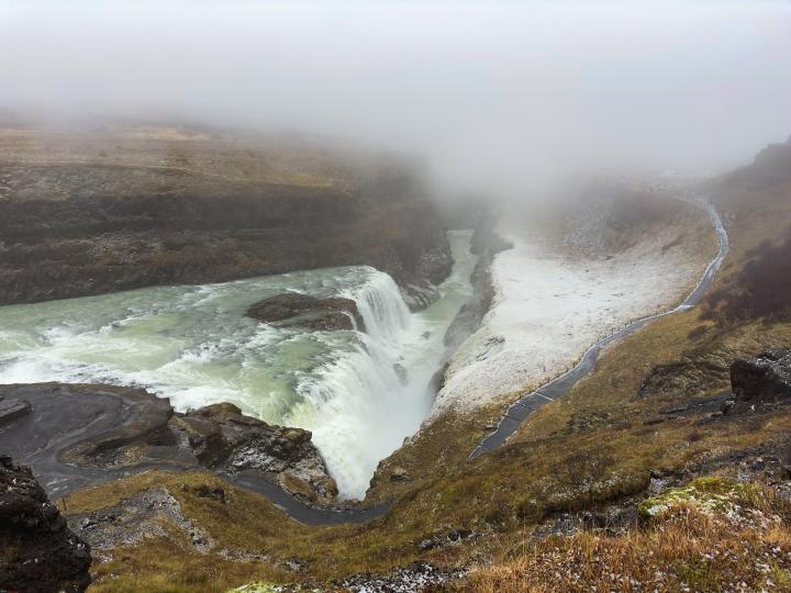
Gullfoss
At 1 PM we reached Gullfoss Parking. It is on Route 806. Waterfall is 400 m walk from parking. This is our first major waterfall in Iceland and we were completely mesmerised by its sheer volume. The Gullfoss, which means “Golden waterfall” is a two-tier waterfall on the river Hvítá. After dropping down 32 m over two main cascades the river continues its journey in a narrow gorge. The name probably comes from the fact that the water droplets sparkle like gold in bright sunlight. We parked our car at the parking space and went to the viewing point at the lower level. You can go all the way up and close to the water in lower level. But during winter this path remains closed due to icy conditions. We climbed up to the upper level. It is clearly written all over that drone is not allowed here. The view from the upper level was amazing. Even though it was raining, we enjoyed the view. The entire area is misty as Gullfoss sprays out a massive volume.

Gulfoss waterfalls

View from upper level
After spending half an hour at Gullfoss, we went to the Gullfoss cafe nearby to grab some lunch. We had a good lunch with Chicken Panini, Ham Croissant, filter coffee and chocolate cake and then bought few small souvenirs.

At Gulfoss Cafe
Friðheimar Tomato Farm and Skjol basecamp

Friðheimar Tomato Farm and Skjol basecamp
It was at 2:15 when we left Gullfoss to go to our next destination - Geysir / Strokkur, which is about 10 km from here. Beyond Gulfoss R35 changes to F35 and is closed in winter except for the SuperJeeps. Anyway, we turned onto route R35 and drove towards our next destination. Due to its geological location over a rift in continental plates , Iceland is brimming with geothermal areas. One of the most visited is Haukadalur geothermal area , where there are a number of hot springs and mud pools. On the way, we saw the famous Friðheimar Tomato Farm at Fludir. You can have tomato soup or tomato beer here. You can also buy tomato or tomato juice. Also beside the farm you have Skjol base camp which is the starting point of many adventure tours like snowmobil, ice cave tour etc. As we had just had our lunch and not much of a tomato fan, we moved on.
Haukadalur
We reached Haukadalur at around 14-30. The Great Geysir is known to have ejected hot water more than 120 m high for many years, but now it is in a dormant phase. However ‘Strokkur’, a nearby smaller geyser is as vigorous as ever erupting every 10 mins and shooting 20 m high fountain of warm water and steam. We spent some happy moments there, trying to catch the exact time of the eruption in the shivering cold. Walking through the area, we came upon few fumaroles. Everywhere around us there are little pools of water bubbling and the air rich in smell of sulphide. It was fascinating to stand amidst those hot geysers and mud pools.

Geothermal area with geysers and mud pools

Little Geysir

Cyclic eruptions of Strokkur
Efstidalur II
At 3:20 pm we started from Geysir. We will go to Borgarness which is 146 km and where we plan to have an early dinner and pick up some snacks and easy to cook food. On the way, we went to visit Efstidalur II farm at Laugarvatn which is famous for ice creams made of milk from their farm bred cows.

Farm at Efstidalur II

Horses in Efstidalur farm
From R37 we took a right turn and drove a bit uphill to reach Efstidalur. It has a horse farm too, where on sunny days it must have been fascinating to go for a horse-ride. There were strawberry, chocolate, banana, blueberry and other regular flavours of ice-cream, but we took ‘Stracciatella’, which is their special flavour and it tasted really good. There are also rooms available for staying in farmhouse. We spent some time seeing the farm horses before moving on to our next destination.

Road climbing down from Esftidalur farm
Ring Road
After leaving Efstidalur II at around 4 PM, we took R37, then at the T junction after Laugarvatn, we drove straight to R365 and we are back in Thingvellier National Park at 4:30 PM. There was snow in some parts of the road.

Towards Ring road
It was raining heavily and we were 87 km from Borgarnes, a picturesque town in West Iceland. We saw a large horse farm on the way, called Laxness horse farm. At about 17-00, we came to a junction, where we meet Ring Road or R1 of Iceland. Here the left road went towards Reykjavik. We turned right towards Akureyri. From here Borgarness is another 56 km. We are now driving on R1, the Ring road. The volume of cars increased as we touched Ring road - doesn’t seem to be a lean season going by the number of cars.
Hvalfjörður tunnel

Hvalfjörður tunnel
When we were 39 km from Borgarnes, we entered the 6 km long Hvalfjörður tunnel under Hvalfjörður fjord.. Speed limit inside the tunnel is 70 km/h. There were cameras inside the tunnel. You do not need to pay toll in this tunnel. We came out of the long tunnel at 5-20 and took a break for 10 minutes at the road-side parking. Outside air had turned much colder than before.
Borgarness
Rain again become heavy after we started but subsided soon. We crossed a picturesque sea bridge just before Borgarness. Just before the bridge, there is a right turn to R50 which goes to Hraunfosser and Barnafoss waterfalls. Hraunfosser is a collection of countless creeks and cascades small and big streaming out of the lava over a distance of 1 km. Had we have time we definitely should have visited there. Anyway, we crossed the bridge and reached N1 gas station at Borgarnes at 6 PM.
The main reason for stopping at the gas station was to have our dinner at the cafe and to buy something for breakfast for the next 2 days . We are going to stay at Dis Cottage near Grundarfjörður which has no restaurant. But there will be a kitchen with all standard facilities where you can cook breakfast. After dinner, we bought a couple of Skyr bowls. Skyr is Icelandic yoghurt, which is available everywhere. If you like yoghurt, you will like Skyr. As it was getting dark outside, we hurried our way across the street to a discount supermarket ‘Netto’, which is open till 7 pm. We bought some eggs, sausages and a small bottle of olive oil for cooking. This last item took some time to find, as most cooking oil comes in 1 Litre bottle. Finally we paid for the items in the self-service counter and came out of the store at about 7 PM.
Grundarfjörður
We started for Grundarfjörður and turned left on to R54 at about 7 PM leaving R1. Dis Cottages is 87 km away. Weather is getting better which was confirmed by our weather boards. At 8 PM, we came to a junction from where the road on our right went towards Stykkishólmur (18 km), which is the largest settlement in this area with 1200 inhabitants . We turned left towards Grundarfjörður. The final 1 km-long stretch was a gravel road, which went up to Dis cottages. We met the landlady, who also lived alongside the cottages and then checked into one standalone cottage. It is a cosy one-room apartment with all amenities including a small kitchen with an induction oven, microwave, toaster, coffee-maker, refrigerator, cups, plates, cutlery, salt & pepper. The brightly lit town of Grundarfjörður town was visible at distance from these isolated cottages. We had our dinner, set up the camera for Northern lights, set up few alarms in case both of us fell asleep and waited for the Aurora... which never appeared, though the sky was clear and chances were high. But such is the probability of an Aurora sighting.
Continue reading brownianmotion's travelogue for BHPian comments, insights and more information.
Find Car News
Just News


About Us

Buy & Sell
USED CARS