Team-BHP > Travelogues
Register New Topics New Posts Top Thanked Team-BHP FAQ


Reply
  Search this Thread
125,048 views
Old 17th August 2010, 00:40   #1
BHPian
 
Join Date: Jul 2010
Location: New Delhi
Posts: 297
Thanked: 844 Times
4500 km, Two Idiots & a Wild Safari in Ladakh

A dream destination for us. It was cancelled at the last moment in October 2008, postponed for a year in Jun. 2009, but when we finally did it in Jun. 2010, it was a trip of a lifetime! A journey filled with adventures and plenty of 4x4 action for a couple driving alone for 17 days in the land of high mountain passes - Ladakh!

The trip gave us a taste of all kinds of adventures - a change of plans at the last moment, a long drive to Leh via Manali & Srinagar, a crazy ride with Kiangs, getting lost near a lake only to discover a relatively lesser used route to the elsuive Chumur, a visit to the charming Hanle, a drive to the beautiful Pangong Tso, conquering the highest "motorable" road in the world - Marsimik La, discovery of another relatively lesser known road from Changthang to Nubra, exploring the border village of Turtuk & finally followed by a crazy drive back home to Delhi via Manali.

The travellers: Aarti & Harsh
The machine: Our very own wild *** - Tata Safari 4x4, we call it Kiyang

The journey covered 4500 km in all and it took us 17 days to do it. Thankfully, both of us drive, making it possible to cover more ground per day without getting too exhausted. .

A glimpse of the photographs to come:


Day 1 (June 10, 2010): Delhi - Manali: 560 km - 14 hrs
4500 km, Two Idiots & a Wild Safari in Ladakh-002_bilaspur_day-1.jpg
One of the submerged temples at Bilaspur

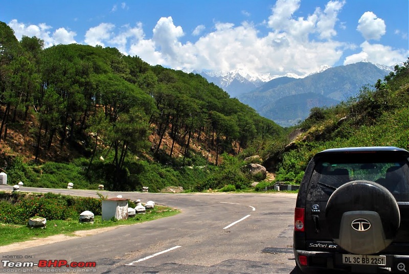
Day 2: Manali - Kangra - Pathankot - Patnitop : 490 km - 15 hrs
4500 km, Two Idiots & a Wild Safari in Ladakh-007_crossing-kangra-valley_day-2.jpg
The drive through Kangra valley

Day 3: Patnitop - Srinagar : 190 km - 7 hrs
4500 km, Two Idiots & a Wild Safari in Ladakh-051_dal-panorama.jpg
The Dal lake at dusk

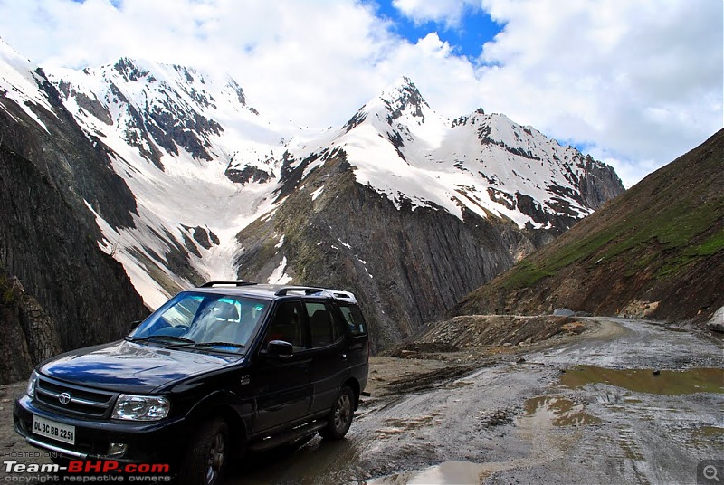
Day 4: Srinagar - Kargil : 200 km - 11 hrs
4500 km, Two Idiots & a Wild Safari in Ladakh-069_at-zozila.jpg
The approach to Zoji La

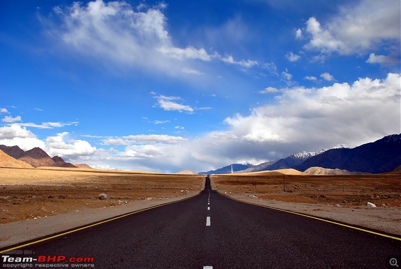
Day 5: Kargil - Lamayuru - Alchi - Leh : 240 km - 12 hrs
4500 km, Two Idiots & a Wild Safari in Ladakh-143_post-saspol.jpg
The last stretch to Leh is a pleasure to drive on

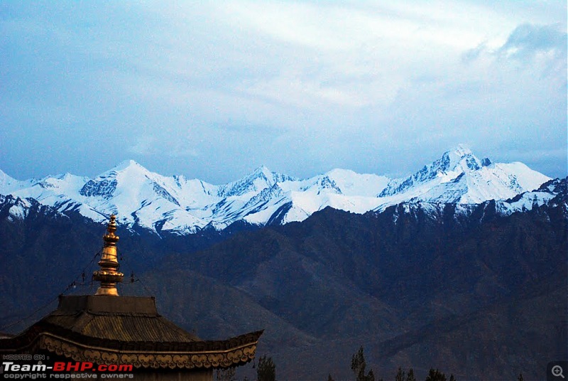
Day 6: Rest day at Leh (permits) : 0 km
4500 km, Two Idiots & a Wild Safari in Ladakh-154_view-rooftop-restaurant.jpg
Evening shot from a rooftop restaurant

Day 7: Leh - South Pullu - Leh - Tso Kar - Tso Moriri : 310 km - 13 hrs
4500 km, Two Idiots & a Wild Safari in Ladakh-207_chasing-kiyang-tso-kar.jpg
Kiyang, with Kiangs

Day 8: Tso Moriri - Chumur - Hanle : 180 km - 10 hrs
4500 km, Two Idiots & a Wild Safari in Ladakh-250_at-tso-moriri.jpg
Our campsite at Tso Moriri

Day 9: Hanle - Loma - Dungti - Loma - Tsaga - Spangmik (Pangong Tso) : 210 km - 10 hrs
4500 km, Two Idiots & a Wild Safari in Ladakh-297_road-hanle-loma.jpg
The wide valley from Hanle to Rhongo

Day 10: Spangmik - Marsimik La - Tangtse : 124 km - 9 hrs
4500 km, Two Idiots & a Wild Safari in Ladakh-379_at-marsimik-la.jpg
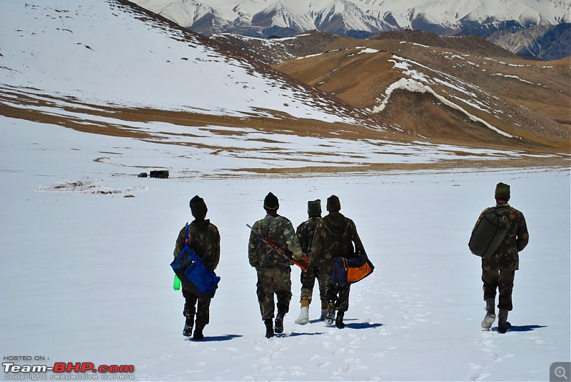
Army men descending from Marsimik La, one can see our Kiyang parked far away with a Stallion

Day 11: Tangtse - Shayok - Agham - Panamik : 150 km - 5.5 hrs
4500 km, Two Idiots & a Wild Safari in Ladakh-408_shyok-village.jpg
The pretty Shayok village

Day 12: Panamik - Hundar - Turtuk : 140 km - 6 hrs
4500 km, Two Idiots & a Wild Safari in Ladakh-441_enroute-turtuk-hundar.jpg
Dramatic colors on the drive to Turtuk

Day 13: Turtuk - Hundar - Khardung La - Leh: 210 km - 8 hrs
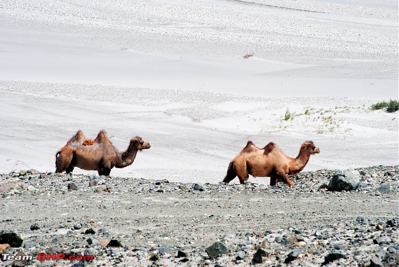
4500 km, Two Idiots & a Wild Safari in Ladakh-466_camels-hundar.jpg
Bactrian camels near THOISE

Day 14: Rest day at Leh : Day visit to Thiksey: 0 km
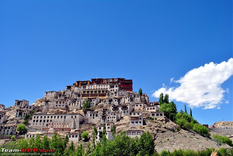
4500 km, Two Idiots & a Wild Safari in Ladakh-486_thiksey.jpg
Thiksey Monastery

Day 15: Leh - Tanglang La - Pang - Sarchu - Baralacha La - Sarchu: 290km - 15 hrs
4500 km, Two Idiots & a Wild Safari in Ladakh-499_river-end-moreh-plains.jpg
Descending from Moreh plains to Pang

Day 16: Sarchu - Baralacha La - Keylong - Manali - Kullu: 260km - 17 hrs
4500 km, Two Idiots & a Wild Safari in Ladakh-544_damaged-road-before-baralacha-la.jpg
A raging icy stream on the road made the climb to Baralacha La awful, or should I say awesome!

Day 17: Kullu - Delhi: 530 km - 16 hrs
4500 km, Two Idiots & a Wild Safari in Ladakh-586_work-road-post-mandi.jpg
BRO clearing a landslide

The map below should give you an idea about the physical locations of these places mentioned above, should you need to refer it at all.
4500 km, Two Idiots & a Wild Safari in Ladakh-mapwith-pointsanddistancesver-3.0.1.jpg
vardhan.harsh is offline  
Old 17th August 2010, 01:08   #2
MX6
Senior - BHPian
 
MX6's Avatar
 
Join Date: Oct 2009
Location: City of seven islands.
Posts: 2,878
Thanked: 233 Times

It's raining Leh logues!
Last I read was a couple who got lost on their way from Bangalore to Sakleshpura. Now I hear another couple who have four by floored this route.
Roll it on dude (and dudette).
Another 5* in the making.
MX6 is offline  
Old 17th August 2010, 01:30   #3
Senior - BHPian
 
nitrous's Avatar
 
Join Date: May 2004
Location: UAE/Lon/Madras
Posts: 6,965
Thanked: 329 Times

This is how a travelogue should be.
Excellent photography.
And the map should be very useful.
Rated 5-stars.
nitrous is offline  
Old 17th August 2010, 02:02   #4
Team-BHP Support
 
BlackPearl's Avatar
 
Join Date: Aug 2005
Location: Calcutta/London
Posts: 3,634
Thanked: 17,135 Times

Great travelogue and awesome pictures.
BlackPearl is offline  
Old 17th August 2010, 07:03   #5
Team-BHP Support
 
ampere's Avatar
 
Join Date: Sep 2009
Location: Bangalore
Posts: 18,182
Thanked: 13,360 Times

Amazing one and as Nitrous said, the map is just perfect.
How did you make that? What is Source? OSM?
ampere is offline  
Old 17th August 2010, 09:44   #6
BHPian
 
Join Date: Jul 2010
Location: New Delhi
Posts: 297
Thanked: 844 Times

Quote:
Originally Posted by MX6 View Post
It's raining Leh logues!
Well, this is the time everyone comes back from Leh, thus the rain of Leh logues.

Quote:
Originally Posted by nitrous View Post
This is how a travelogue should be.
Excellent photography.
And the map should be very useful.
Rated 5-stars.
Thank you nitrous

Quote:
Originally Posted by BlackPearl View Post
Great travelogue and awesome pictures.
Thank you blackpearl

Quote:
Originally Posted by ampere View Post
Amazing one and as Nitrous said, the map is just perfect.
How did you make that? What is Source? OSM?
Thanks ampere. Well we needed a unified map of the interiors of Changthang for the trip and there were none that we were able to find. We also required GPS tracks of the region, and were not aware of OSM till then. So we started to mark our travel plan on Google earth, by referring to other available maps and distances as given by other maps. In some cases measuring the distance on google earth itself and using a factor of 1.4 or 1.5 (depending on how many switchbacks the route had).

Once the path was marked on Google earth, we exported only the road to Adobe photoshop and made a map out of it. Refined it further after the trip with actual distances of the roads we traveled upon. In some cases, we also used GPS tracks of other members such as tsk1979 (Kyun Tso -> Nyoma stretch). Needless to say it took quite a lot of time to make this, but in the end it was worth it.
vardhan.harsh is offline  
Old 17th August 2010, 09:54   #7
BHPian
 
Join Date: Feb 2007
Location: CCU & Ontario
Posts: 610
Thanked: 158 Times

One of the best Leh travelogues so far. This really stands out from the rest.

Excellent photography. What is your equipment?
Saurabh M is offline  
Old 17th August 2010, 10:02   #8
BHPian
 
hemanthisgreat's Avatar
 
Join Date: Jul 2007
Location: Bangalore
Posts: 594
Thanked: 51 Times

Excellent travelogue, with great photos. Rating this ***** as I have already read the whole travelogue and know its great. So what are you waiting for, go ahead and post the rest of it.
hemanthisgreat is offline  
Old 17th August 2010, 10:11   #9
BHPian
 
Join Date: Jul 2010
Location: New Delhi
Posts: 297
Thanked: 844 Times
Day 1 (June 10, 2010): Delhi - Manali: 560 km - 14 hrs

Everything was finally set! Our Safari, Kiyang, was with us, leaves from work had been applied for, and excel sheets had been drawn up! The preparation for the trip had begun soon after our brief trip to Binsar in April. Since time was short, a methodical way of planning was necessary. Since we both are working and have little time apart from Sundays to get any work done, we decided to manage things effectively by splitting the tasks and bit by bit arranging items required for the trip.

The most difficult things to procure were the accessories for the car including snow chains and a towing cable. However, a meet up with a TBhp member, Aman, at his Noida garage convinced us not to take snow chains. As for the towing cable, it was quite a while before we found a good one, and if I remember correctly, it was a BMCTian (RKBharat) whose post helped us out eventually.

As the D-day kept getting closer, the weather started playing tantrums. Nevertheless, we were sure that we would be able to do the Manali-Leh highway easily, and it was further supported by the fact that 5 days before our leaving we got reports that vehicles had started crossing Baralacha La.

But I guess the weather gods had something else planned. 2 days later, heavy snowfall forced Baralacha La to close down again. It was then that we decided that getting snow chains might be the apt thing to do given the current weather conditions. We pressed the panic button, but were not able to find them anywhere in Delhi. Finally, we managed to get a contact in Shimla via Aman, who promised to deliver the snow chains to us in Delhi one day prior to our departure. We took the deal, and thankfully he kept his promise.

So armed with our Nikon D3000 with a new 70-300 mm zoom lens, we left for Manali, still hopeful of doing the Manali-Leh highway. We had become increasingly despondent that we would not be able to cover all that we had planned, having made the wrong assumption that if Rohtang & Baralacha La are closed, most of the passes in Ladakh would also be! So the plan was to cross Rohtang, if it was open, the next day, and roam about in upper & lower Lahaul till Baralacha La relents. However, fate had something completely different planned for us and our original itinerary literally went for a toss!
4500 km, Two Idiots & a Wild Safari in Ladakh-01.jpg
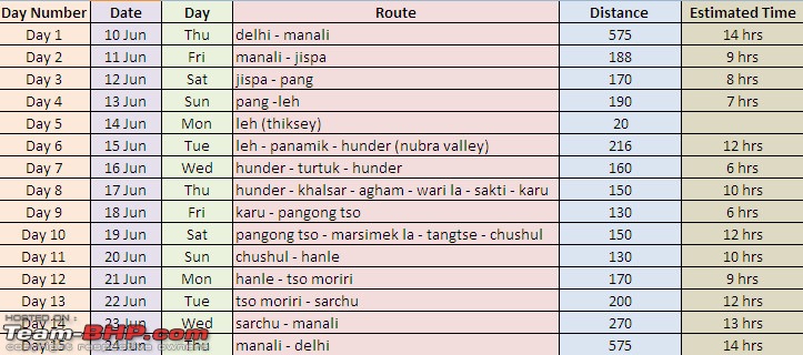
Our original plan without Chumur with 2 buffer days

We left our house at about 3:30 on the 10th of June, without further incidents managed to cross Chandigarh by 8, and reached Bilaspur by 11 am. The submerged temples, with green patches around, were looking as beautiful as ever, and we decided to go down to click some pictures. However, we were not able to find our way and after some offroading misadventure, decided to abort the plan and moved on towards Manali.

4500 km, Two Idiots & a Wild Safari in Ladakh-002_bilaspur_day-1.jpg
One of the submerged temples at Bilaspur

Our regular trips to Himachal meant that our route and time schedule to Manali was more or less fixed - leave Delhi early to reach Manali in time for a late lunch at our favourite joint, Il Forno. As the Outlook Traveller Himachal guide says, the owner of Il Forno, an old lady, "is from Naples and her pizzas are from heaven"! .

As we approached Manali, it started raining, further dampening our hopes of crossing Rohtang the next day. Even while having lunch, we could see the storm on the peaks visible from there, and knew that it was not a good sign.

4500 km, Two Idiots & a Wild Safari in Ladakh-003_manali-peaks-il-forno_day-1.jpg
Zoomed view of a storm on the peaks visible from Il Forno


After checking into a hotel, we wandered about, asking local taxi drivers about the road condition up ahead. All of them painted a very grim picture, and said that it would take at least another day for Rohtang to open, and a good 5 for Baralacha to open. One taxi driver explained to us at length the exact situation, saying that he'd been there a couple of days back, and elaborated how glaciers had come on to the road. According to him, the highway would take at least another 10 days to get completely open till Leh.

But as they say, every dark cloud has a silver lining, and soon after talking with him we got to know (via Tanveer, tsk1979) that the road till Hanle is open. We were overjoyed at this piece of info, and our earlier fear of roads and passes in Ladakh being closed was washed away. We then immediately decided on taking the alternate route to Leh via Srinagar, so that we do not lose time and are able to at least cover all that we'd planned for Ladakh. The idea was that the Manali-Leh highway could always be covered on our way back. Thereafter, we took out our maps, added up kms, made an alternate itinerary, and went off to sleep. The next night halt would be Patnitop, a good 500 km or so away, and we needed a good night's sleep.
vardhan.harsh is offline  
Old 17th August 2010, 10:15   #10
BHPian
 
Join Date: Jul 2010
Location: New Delhi
Posts: 297
Thanked: 844 Times

Quote:
Originally Posted by Saurabh M View Post
One of the best Leh travelogues so far. This really stands out from the rest.

Excellent photography. What is your equipment?
Thanks Saurabh (Makkar?) We used a Nikon D3000 with one stock lens (18-55m) and one zoom lens (70-300mm).

Quote:
Originally Posted by hemanthisgreat View Post
Excellent travelogue, with great photos. Rating this ***** as I have already read the whole travelogue and know its great. So what are you waiting for, go ahead and post the rest of it.
Thanks Hemant, Yeah, I'm just transferring the travelogue on to T-BHP. . I guess you read it on the other forum. Will be rapidly updating over here, since it involved copying & pasting only.
vardhan.harsh is offline  
Old 17th August 2010, 10:50   #11
Team-BHP Support
 
ampere's Avatar
 
Join Date: Sep 2009
Location: Bangalore
Posts: 18,182
Thanked: 13,360 Times

Quote:
Originally Posted by vardhan.harsh View Post
Thanks ampere. Well we needed a unified map of the interiors of Changthang for the trip and there were none that we were able to find. We also required GPS tracks of the region, and were not aware of OSM till then. So we started to mark our travel plan on Google earth, by referring to other available maps and distances as given by other maps. In some cases measuring the distance on google earth itself and using a factor of 1.4 or 1.5 (depending on how many switchbacks the route had).

Once the path was marked on Google earth, we exported only the road to Adobe photoshop and made a map out of it. Refined it further after the trip with actual distances of the roads we traveled upon. In some cases, we also used GPS tracks of other members such as tsk1979 (Kyun Tso -> Nyoma stretch). Needless to say it took quite a lot of time to make this, but in the end it was worth it.

That is really an amazing effort Harsh. Thanks for sharing.
ampere is offline  
Old 17th August 2010, 11:01   #12
BHPian
 
Join Date: Nov 2006
Location: London
Posts: 442
Thanked: 67 Times

Excellent photos! Tata Motors may be interested in some of the snaps to be used as promotional material for the Safari.

However, please refrain from scaring animals (atleast the photo said so)
Jeep is offline  
Old 17th August 2010, 11:09   #13
Senior - BHPian
 
aargee's Avatar
 
Join Date: Jan 2010
Location: TSTN
Posts: 6,313
Thanked: 9,901 Times

The pic on saspol (143_Post Saspol.JPG) reminds me of drive through Nevada; and 207_Chasing Kiyang at Tso Kar.JPG looks like you're driving in a African safari. Wow, what a diversity in one country. Rated ***** already.

Quote:
Originally Posted by vardhan.harsh
Once the path was marked on Google earth, we exported only the road to Adobe photoshop and made a map out of it
Excellent to hear & kudos to the effort.

Last edited by aargee : 17th August 2010 at 11:10.
aargee is offline  
Old 17th August 2010, 11:15   #14
Team-BHP Support
 
tsk1979's Avatar
 
Join Date: Feb 2005
Location: San Jose, CA
Posts: 23,727
Thanked: 23,140 Times

Good to see you here Harsh! Bring it on.
tsk1979 is offline  
Old 17th August 2010, 11:29   #15
BHPian
 
Join Date: Aug 2009
Location: Lucknow
Posts: 785
Thanked: 115 Times

Quote:
Originally Posted by MX6 View Post
Another 5* in the making.
It was a 5* TL from the beginning. All the Leh TLs are like that, but, yes, just like Sapna-Chandan TL, this is different.

Excellent pics and courageous journey. Waiting to hear the story in detail plz.
LongDrive lover is offline  
Reply

Most Viewed


Copyright ©2000 - 2024, Team-BHP.com
Proudly powered by E2E Networks