| |||||||

| Search Forums |
| Advanced Search |
| Go to Page... |
 |
| Search this Thread |  725,406 views |
 23rd August 2017, 20:56
| #466 |
| BHPian | Re: Delhi-Kolkata by Road | NH2 (now called NH19) in full detail Safely completed the Kolkata NCR trip & happily anchored at Indirapuram.  Drove very carefully to take care of my RFTs. Road condition in Bihar & Jharkhand was a mix bag. There was a severe traffic knurl on departure at Vidya Sagar Setu at 0500 hrs, resulted in a delay on 1.5 hrs at the beginning. Then followed by some further delays due to diversions after Panagar, traffic / bad roads in JH + Bihar. And worth mentioning of numerous diversions after Dehri On Son (stopped counting) till Varanasi. Roads are super smooth from Allahabad by-pass to arrival NCR (except a small section from Etawah till ALE). Total toll paid = 1800/- Thank you SS Da and other BHPians of this thread, I could visualize this route even before I was on it.  Cheers Sail |

|  (3)
Thanks (3)
Thanks
|
| The following 3 BHPians Thank Sail for this useful post: | no1lives4ever, Sheel, SS-Traveller |
| |
|
25th August 2017, 17:35
| #467 |
| BHPian Join Date: Sep 2015 Location: KOLKATA INDIA
Posts: 426
Thanked: 1,561 Times
| Re: Delhi-Kolkata by Road | NH2 (now called NH19) in full detail If all goes as per plan, I intend to drive it down from Kolkata to Delhi, departing Kolkata on 30th November at 4 AM. Night halt at Varanasi. 1st December, start from Varanasi by 6 AM and drive to my uncle's place at Greater Noida. 2nd December drive to my parents place at Dwarka. This drive shall be solo, on the return a friend shall accompany me. Start from his place (Preet Vihar) on 8th December at 12 noon. Night hault at Agra. Leave early for Varanasi as we want to see the aarti on the Ganga. Next day start for Kolkata. |
|
| (1)
Thanks
|
| The following BHPian Thanks ALTIMAed for this useful post: | SS-Traveller |
|
6th September 2017, 13:41
| #468 |
| BHPian Join Date: Feb 2007 Location: New Delhi
Posts: 79
Thanked: 59 Times
| Kolkata to Delhi route query I am planning a road trip from Kolkata to Delhi in end of Sep 2017. The trip will start before Durga Pujas. The plan is to do the trip over 2 days. We plan to start early from Kolkata early in the day around 5-7am and take a night halt at Varanasi for Day 1. On day 2 the plan is to leave varanasi by 9am or so. Google Maps Is showing this route which is via Durgapur, Asansol, Dhanbad, Chouparan, Aurangabad, Mughal Sarai with travel time between 12.5-15 hours.  There is an alternate route shown via patna, but that is shown with much longer times. Should I be considering that route over this one. Day 2 route is shown as: Via Allahabad, Kanpur, Etawah on AH1 and Karhal to Agra on Lucknow expressway and from Agra to Delhi on Yamuna Expressway.  Detail of Etawah to Agra stretch  Vehicle used to travel would be a 2016 Petrol Honda City. How safe is this route for travelling with women and children. Any stretches I need to be careful about? How is the road surface on this route? Any stretches with potholes or lots of speed breakers? Any suggestions on restaurants and places to halt for rest and refreshments. What about petrol pumps, I guess I would need to tank up a few times through the journey. -- no1lives4ever |
|
| ()
Thanks
|
|
6th September 2017, 13:58
| #469 |
| Distinguished - BHPian  Join Date: Nov 2007 Location: Belur/Bangalore
Posts: 7,147
Thanked: 27,205 Times
| Re: Kolkata to Delhi route query There is already an existing thread with the latest details between Delhi and Kolkata. Please refer here and post your queries: http://www.team-bhp.com/forum/travel...detail-32.html Have reported to mods to merge this onto the above thread. |
|
| (2)
Thanks
|
| The following 2 BHPians Thank paragsachania for this useful post: | BlackPearl, no1lives4ever |
|
17th September 2017, 15:59
| #470 | |||
| BHPian Join Date: Feb 2007 Location: New Delhi
Posts: 79
Thanked: 59 Times
| Re: Delhi-Kolkata by Road | NH2 (now called NH19) in full detail So I went through this thread and got lots of answers to my queries. I still have some remaining queries, so posting them here.. 1. What is the best route to get into and out of Varanasi. I would be staying around JHV mall area. Quote:
 So based on my destination, I should be taking this route:  Google maps says that this route is around 7 kms longer and should take me 10 mins more than this route, which it is suggesting:  Which of the 2 above routes should I consider? Any pitfalls with either of these routes? Also are the original routes shown on google maps the ones that were actually suggested or have they changed with updates done to google maps? 2. For exiting varanasi, again similar queries.. Quote:
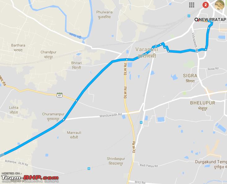 And giving me similar exit route from around JHV mall, except for a different route to account for the different starting points inside the city.  I hope there are no major surprises with the above route for getting out of Varanasi. For exit, I would also ask people at my hotel and any taxi driver I may find around there for additional points. I also have a query regarding the best point to connect to agra lucknow expressway. Is the route suggested by google below (via Etawah and Karhal) to connect to the expressway at the Mainpuri Exit. Quote:
 -- no1lives4ever Last edited by no1lives4ever : 17th September 2017 at 16:04. | |||
|
| ()
Thanks
|

|
17th September 2017, 22:08
| #471 | ||
| Distinguished - BHPian | Re: Delhi-Kolkata by Road | NH2 (now called NH19) in full detail Quote:
Quote:
Last edited by SS-Traveller : 17th September 2017 at 22:09. | ||
|
| ()
Thanks
|
|
17th September 2017, 22:54
| #472 | ||
| BHPian Join Date: Feb 2007 Location: New Delhi
Posts: 79
Thanked: 59 Times
| Re: Delhi-Kolkata by Road | NH2 (now called NH19) in full detail Quote:
Quote:
Overall I have had very good experience with google maps navigation in various parts of India over the past 2-3 years. They have pretty decent traffic information and unless one has very specific local knowledge the google navigation seems to send one through the fastest routes in most cases. I will be doing the trip this weekend and I will report on the exact route taken and the kind of traffic I faced. -- no1lives4ever | ||
|
| (1)
Thanks
|
| The following BHPian Thanks no1lives4ever for this useful post: | SS-Traveller |
|
18th September 2017, 07:55
| #473 |
| Team-BHP Support  | Re: Delhi-Kolkata by Road | NH2 (now called NH19) in full detail Getting in and out of Varanasi is a royal pain. I have been to Varanasi twice, once in Feb '16 and last month in August. Took me more than an hour and traffic is maddening plus it is a furnace. Varanasi or any place, I will prefer a motel at the outskirts/bypass. |
|
| (1)
Thanks
|
| The following BHPian Thanks Sheel for this useful post: | no1lives4ever |
|
18th September 2017, 13:01
| #474 | |||
| BHPian Join Date: Mar 2013 Location: KOL-DEL-LKO
Posts: 720
Thanked: 3,525 Times
| Re: Delhi-Kolkata by Road | NH2 (now called NH19) in full detail Quote:
Quote:
Quote:
Regards, Pawan | |||
|
| (1)
Thanks
|
| The following BHPian Thanks PapaBravo for this useful post: | no1lives4ever |
|
18th September 2017, 14:43
| #475 | |||
| BHPian Join Date: Feb 2007 Location: New Delhi
Posts: 79
Thanked: 59 Times
| Re: Delhi-Kolkata by Road | NH2 (now called NH19) in full detail Quote:
Any specific reason why you ask me to avoid this road. Is this road not good one to take on my way out during morning time? What are the concerns about this road? In any case, I guess this route's condition would be answered by the hotel people at Varanasi as I would be using it to get out of Varanasi before I use it to get into the city on my return leg. I see that the section where you are asking me to not take a left is a road where gmaps has no traffic data and it seems like a narrow congested road through the city. So based on my Udaipur experience, I would suppose that this road is either closed to vehicles or so congested that google is not able to collect traffic stats. Is this what you tried to warn me about? I also see a level crossing on the image that may or may not be permanently closed Quote:
Quote:
 -- no1lives4ever Last edited by no1lives4ever : 18th September 2017 at 14:50. | |||
|
| ()
Thanks
|
|
25th September 2017, 00:39
| #476 | |
| BHPian Join Date: Feb 2007 Location: New Delhi
Posts: 79
Thanked: 59 Times
| Re: Delhi-Kolkata by Road | NH2 (now called NH19) in full detail I did the trip starting yesterday morning and am back in Delhi now. Writing this post now before I forget the details. Road conditions were quite good for most of the way. Below is a more detailed trip report. Warning, very long post  At the start, we faced a major traffic jam on the so called Kona expressway. That highway is more or less a 4 laned national highway. But there is a major bottleneck at Santragachi. There the flyover over the railway tracks is only a two laned affair and because of that there is major traffic jam both before and after that flyover. In addition, there are a bunch of traffic signals that further slow down traffic. I think it is best to avoid this road early in the morning. Even google maps does not really suggest this route. Dankuni onwards, the Durgapur expressway was pretty decent. I faced no real issues and while there were some people crossing the road and some vehicles coming in the wrong direction, those were present everywhere else on the route, including on the almost empty agra lucknow expressway and even on the yamuna expressway. I was able to hit decent speeds on this stretch when traffic permitted. Traffic was light as compared to other sections. I wanted to stop at an ATM along the way and we did not find any on the durgapur expressway. The first ATM that we found on the highway was in Jharkhand. Durgapur onwards, there were lots of diversion due to under construction flyovers. The first one where we had to spend some major time was in Raniganj (i am not 100% sure). Thereafter we faced some congestion at Govindpur. The road till around dhanbad is undergoing 6 laning and the sections in between the diversions is quite nice. I could maintain decent speeds here. There was at least one non functional toll plaza on this section. Jharkhand roads had some issues with tyre ruts and I did face issues with virtual speed breakers around a few culverts, but overall i was able to maintain good speed as and when traffic permitted. There were some nice scenery and not too many locals on the roads. Villages and towns were spread out and overall Jharkhand was pretty chill. The 3 wheelers started showing up once we got into Jharkhand and did not leave our side till we left NH2 around Etawah. The first major congestion was at a toll plaza around Beko/Aoura in Jharkhand. At the beginning of the congestion, I tried to follow some cars in the wrong direction, but soon after police forced us into the congestion. Google showed this as a 21 min delay, but it took us 1 hour to cross this after mostly spending time on the road shoulder wherever we could. Worst part of this toll congestion was that we did not even have to pay any toll for our passenger car. The population density seemed to go down soon after we crossed Dhanbhad area and then started picking up after we passed the hilly section and closer to Bihar. Jharkhand Bihar border was easy and once into Bihar traffic increased and so did the population density. But I did not face any major congestion in the Bihar stretch and was able to continue maintaining decent speeds along the way. Somewhere along the way 6 laning started, I dont remember if it was in Bihar or Jharkhand, but the under 6 laning status was there for most of the remaining sections of NH2 till around Kanpur. In these sections there were many diversions, but most of them could be done at speeds > 50km/h. The only problem was that there were many speed bumbs around the diversions. A few of them were pretty bad and I remember one in Dehri on Sone that was really nasty since I was not really expecting it. You can see the diversions from a distance and they are all properly marked with reflective signs, so if you see one, then expect a speed bump sometime before and within the diverted route and drive accordingly. The bihar up border has another major bottleneck and I was able to pass this by following a local bus that went the wrong way. One has to be careful about this section. Once into UP, the local traffic really started. The frequency of the 3 wheelers increased and so did the frequency of the two wheelers. But one can still maintain decent speeds if one is careful. Another thing that I noted on the entire NH2 section was that trucks would mostly drive on the rightmost lane and expect others to overtake from the left. Post varanasi I even saw local roadways buses do this. And if you get stuck behind one in a small town, you can frequently overtake that bus from the left, but not always. One has to weave around traffic if one wants to maintain decent speed. If you expect trucks to move aside for you to overtake from the right, then forget it. Post nightfall I was able to not do as high speeds as I could in the day and I followed google maps suggested routes for most parts into varanasi. I entered via the bridge above mughalsarai station. It took me around 1 hour to reach JHV mall in varanasi from the turnoff for mughalsarai on NH2. The entire strech was more or less a 2 laned highway with a divider in between and tons of two wheelers everywhere. In the morning, I tried to follow google maps and saw one instance where it tried to ask me to take a turn into a road that would only allow 2 wheelers. Post that I stuck to the GT road to get out of varanasi and join NH2. Inside Varanasi, there is a flyover under construction around the railway station, so this adds even further to the congestion. We left Kolkata at around 6:15 am and reached Varanasi at around 8pm. This was with a small stop at shaktigarh and another around We left Varanasi at around 9:12am and reached GT road by 10am. Post that The road was for a long time 4 laned with some sections passing through towns with only 1 lane available for highway traffic, and the other being taken up by 3 wheelers, shops and goods. Traffic was quite heavy in the morning time and I had to do a lot of weaving around the traffic. In between the towns I could do decent speeds and did not find any real congestion till I hit allahabad bypass. When I entered allahabad bypass, i was diverted onto the opposide lane and had to go on that for around 8-10km. Somewhere near the end of this diversion i noticed that a truck had an accident and was blocking the entire highway. Post this diversion, the bypass was quite nice. I could maintain good speeds for most parts. There were a few cases of one truck overtaking another, but not too many. I also noticed that the locals have managed to make entries for vehicles from the service lanes on the side onto this road and they freely ride in their motorcycles and also go on the other side of the highway with their cars. In addition there are The roads between allahabad and kanpur were quite good and I was again able to maintain decent speed on this strech. The traffic was less than on the varanasi allahabad section. Kanpur flyover was pretty empty today and I was able to cover it in good time. Post kanpur, the highway was 6 laned and most larger villages and towns were bypassed with flyovers. There were still some settlements on the roadside, but these were few. I found very little traffic on this road and was able to make great speed. This was the fastest section for me till I hit the expressways later on. The etawah highway is 4 laned and did not have much traffic on it. Post etawah, I followed google maps direction and took the etawah-mainpuri highway and joined the agra lucknow expressway from around karhal. The etawah-mainpuri highway is also 4 laned and did not have too much traffic. There were higher than normal levels of cows on this highway. The agra lucknow expressway was nice, pretty empty and has great surface. I was able to maintain very good speeds here. There were some diversions on this expressway. I will post my ALE updates on the relavant thread. Agra inner ring road was nice and with not too much traffic. The toll plaza here also was non functional. Yamuna expressway had quite a bit of traffic and tons of people who would hog the overtaking lane and not budge out. The noida greater noida expressway was also heavily crowded. Today we left varanasi at 9:12am and reached my home in chittaranjan park by 8pm. On the first day, I noticed that google maps estimated arrival time was pretty accurate. Live traffic is pretty well updated on the NH2 and from NH2 to varanasi via mughalsarai, it was estimating around 4-5 mins more than what it took. Google navigation is still not foolproof, but outside varanasi city, it was pretty spot on. I think you can safely use google navigation, to let you know of eta and to stay updated on congestions. Also dont take detours though side roads, etc if you are going to use google maps. Stick to main roads and to routes suggested on the highway signs. I avoided a small detour suggested by gmaps before mughalsarai turnoff after noticing that google was not showing any congestion and that traffic was moving along nicely along the route. Post entering UP, I saw tons of dead dogs. These were everywhere. I dont remember if I saw any dead dogs on the yamuna expressway or on the noida expressway today. I even saw 1 dead cow before etawah. Quote:
Last edited by no1lives4ever : 25th September 2017 at 01:00. | |
|
| (3)
Thanks
|
| The following 3 BHPians Thank no1lives4ever for this useful post: | gmhossain, Nohonking, Wanderers |
| |
|
12th October 2017, 13:09
| #477 |
| Senior - BHPian | Re: Delhi-Kolkata by Road | NH2 (now called NH19) in full detail I 've been a silent visitor to this thread for quite some time and was waiting for an opportunity to post a query once some Delhi-Kolkata driving plan pops up in the horizon . In a gist, I am planning (still in a nascent stage) for a Noida-Kolkata drive (& back) in December in my truck (V-Cross). Taking all constraints in loop, following looks like a tentative plan: a. Start from Noida: Post noon on 6th December (morning start somehow not possible because of some work) b. Start for return journey from Kolkata: On 20th or 21st December morning c. I need to reach Kolkata preferably on 7th night or 8th morning. Queries are: 1. How the journey & stop-over could be planned to make the onward journey in 1 and 1/2 days (6th noon to 7th night), if at all. Else the closest to make it by 8th morning. 2. What could be the fog condition during the 3rd week of December (while returning back) on the route 3. Anyone else making a plan around similar time-frame? |
|
| ()
Thanks
|
|
12th October 2017, 14:18
| #478 | ||
| BANNED | Re: Delhi-Kolkata by Road | NH2 (now called NH19) in full detail Quote:
Please target Allahabad or Fatehpur (70 km before Allahabad) Fatehpur is 650 km from Noida, however you can do it easily in 9-10 hours. You need to start early next day and expect to reach Dankuni by 10 PM. Ideal Case If you want to reach early, please stretch on day 1 and drive all the way till Varanasi. This is also help you skip the local traffic on NH near Varanasi (as it would be around 11 PM) You can stop on highway itself and could afford to start little late on 7th morning. Most optimistic Case You drive all the way, out of UP and stay at Bihar Tourism Hotel at Mohania (Hotel Kaimur) This would be 13-14 hour drive but safe and peaceful one. Quote:
Last edited by Wanderers : 12th October 2017 at 14:26. | ||
|
| (1)
Thanks
|
| The following BHPian Thanks Wanderers for this useful post: | Kandisa |
|
13th October 2017, 10:12
| #479 | |
| BHPian Join Date: Feb 2007 Location: New Delhi
Posts: 79
Thanked: 59 Times
| Re: Delhi-Kolkata by Road | NH2 (now called NH19) in full detail Quote:
Fog can appear randomly around open fields around ponds/rivers and there is no way to predict when and where you would have fog. As such it is mostly a function of the weather on a particular day. In general it is a good idea to assume that you will hit some fog in the month of December and plan accordingly. -- no1lives4ever | |
|
| (3)
Thanks
|
| The following 3 BHPians Thank no1lives4ever for this useful post: | Kandisa, Nohonking, Wanderers |
|
13th October 2017, 12:30
| #480 |
| BHPian Join Date: Sep 2015 Location: KOLKATA INDIA
Posts: 426
Thanked: 1,561 Times
| Re: Delhi-Kolkata by Road | NH2 (now called NH19) in full detail My Kolkata Delhi (solo), Delhi Kolkata (with a friend / solo) drive plans are frozen and the itenary is as follows 28th November 4 AM depart from Kolkata, night halt at Hotel Kaushik, Varanasi 29th November 6 AM depart from Varanasi, night halt at my Uncle's place at Greater Noida 30th Novermber 6 AM depart from Greater Noida to Dwarka. (I do not want to reach Dwarka at night as my parents sleep off pretty early, add to that an opportunity to meet my Uncle after a long time). RETURN Option 1 (if my friend joins me) 10th Dec depart Dwarka at 8 AM, head to Preet Vihar 10th Dec depart Preet Vihar at 12.30 PM, night halt at Sterling Resorts, Agra 11th Dec depart Agra at 5 AM, night halt at Hotel Kaushik, Varanasi. Plan is, after checking into the room, freshen up, then go to see the evening aarti at the ghat (ofcourse, take an auto) 12th Dec depart Varanasi and reach Kolkata 13th and 14th at Kolkata, 15th head out to Puri. Option 2 (if solo) 10th Dec, depart Dwarka at 2 PM for Greater Noida, night halt Greater Noida 11th Dec, depart Greater Noida at 4 AM, night halt Hotel Kaushik, Varanasi 12th Dec, depart Varanasi at 5 AM, towards Kolkata Anyone driving on this route during these dates, please let me know. |
|
| ()
Thanks
|
|