The Introduction
In the Indian context, there are numerous automobile navigation options available around us today that aid in guiding our vehicles to destination. These vary from navigation features in-built into the infotainment system that come with pre-loaded maps, to dedicated external Navigation devices of the likes supplied by Garmin, MapMyIndia, etc to name a few.
However the one that is cheapest (and some being paid) and most popular in masses is the category of mobile device based navigation apps since all that is required is to download the app and one can get started. There are numerous videos on youtube and online reviews citing how these compare against each other but a true comparison in Indian context seems to be rare, given that the accuracy of the maps and the information are bound to vary from country to country. So here I am, presenting my experiences on using some of the more popular ones that I could use during my last long road trip to
Vizag (Journey to Simhachalam & Visakhapatnam in an Innova Crysta).
Of course the comparison below does not cover the exhaustive list of apps available out there in the market and I encourage everyone who has tried these or one of the other apps not listed here to post their own opinions and experiences.
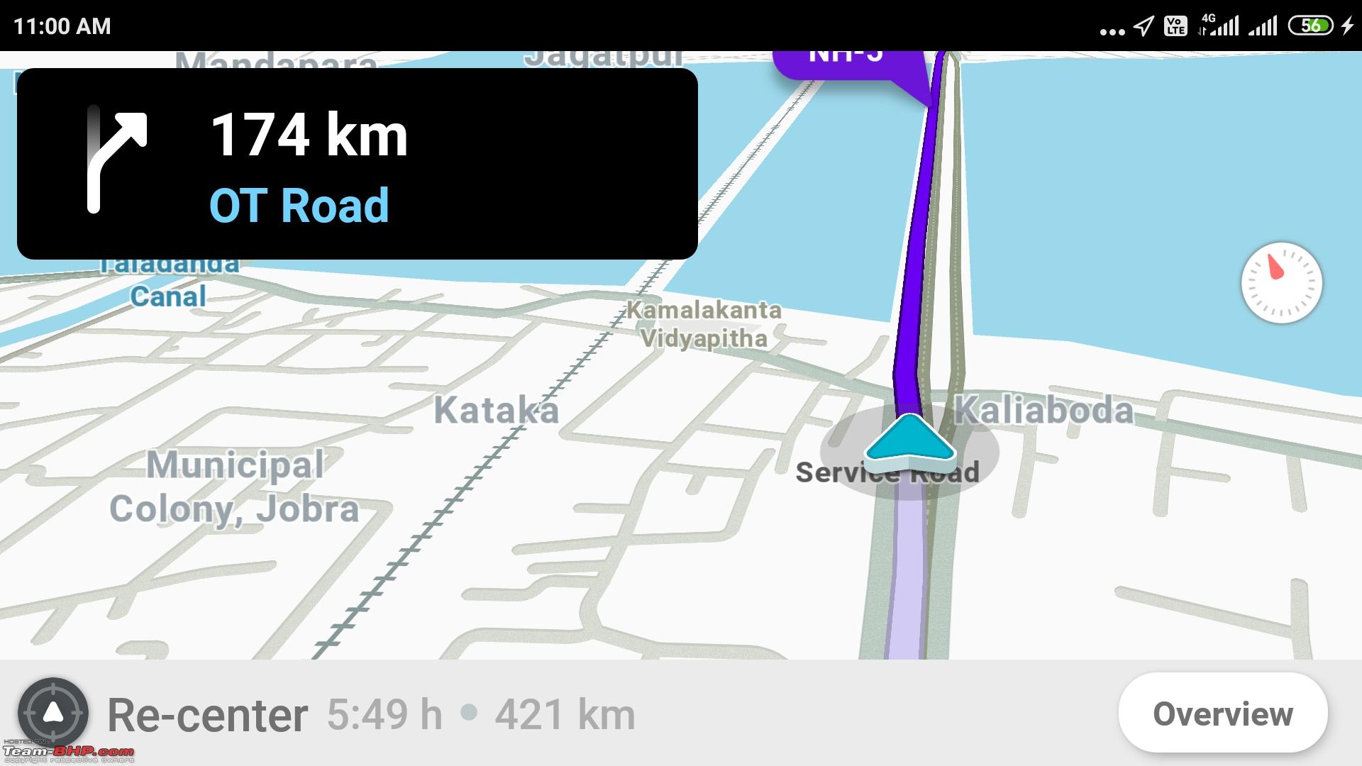
Sygic - Sygic offers a premium paid map service and first 7 days is full feature trial and also comes in various avatars
 The Good Things
- Lane assist feature - When you come to a road junction where you being on go need to quickly get into the right lane, it zooms the map in an inset frame and shows you which lane to take for easier illustration.
- Petrol pumps - Shows you the next closest two petrol pumps on your route with time to reach the first one, this is useful on longer highway trips
- Augmented Reality - Project the direction on the road view itself captured through your mobile camera.
- Dash Cam Mode - Automated recording of mobile camera footage if the speed crosses a certain limit
- Local Business information - Limited to Metro City bounds mostly, outside it is limited or non-existent
- Road info - Shows Speed limit, Time to reach destination, location details on map
- Mirrorlink Support - Those of who uses this will know, this one of the limited navigation apps that support screen projection on a Mirrolink connection (like in my Innova Crysta)
- Community Collaboration - One of the few mobile apps in India that allow reporting for Speed cams apart from regular road closures, etc.
The not so Good Things- Petrol pumps - Although it shows you the next two petrol pumps on your route, yet it does not tell you if its on the same side of the road you are travelling or on the opposite side. This matters a lot in highways as openings / provisions to go to the other side of the road may be non-existent or after few miles and the distance can vary. So it may be of little to no use unless you carry an oil can / bottle to park your car on one side of the highway and take extreme risk in walking to the other side in times of emergency. Also this information is outdated as I noticed in some cases it says there is a petrol pump ahead but that is no longer there or has closed down.
- Street details - While you are on the main road the level of details it shows for the local business is okay for the cities but in highways this becomes limited and moreover the alternative routes or details of smaller lanes that can get you our of traffic / other road closure situations in case of emergency is not much to talk about. So practically it sticks mostly to main roads / highways while showing routes.
- Route updates on traffic, closure, etc - Feature wise this is present but I failed to see this in action as road diversion, traffic related delays are not accounted in the trip's estimated end time. Moreover this is part of Premium feature so after your 7 day trial this will be enabled only after purchasing premium license.
- Speed limit - I observed on the highway it shows 75 (as in the screenshot) in place of 80, 65 in place of 70, consistently 5 km/h less than the actual limit on the highway. Also in some cases the speed limit is outdated if you tally with the sign posts on the road.
- Heavy Initial Download - This is one thing I never liked, while in India many users still run on daily limit based mobile internet plans of 1 GB / 1.5 GB / 2 GB per day, etc this app required you to download the map of your city / region prior to getting started which say for India is around 1.8 GB of initial download and can exhaust your daily internet quota unless you plan in advance.
- GPS Lock - The GPS lock for your present location takes a lot of time to settle, especially if you are planning the trip indoors. Not sure why this problem happens, probably its how it connects to the satellites.
- Alternate Routes - No option showed for alternate routes for the same destination.
Waze - A completely free navigation app, Google bought them in 2013 and ever since some of their features have been inducted into Google Maps, read on to find out
 The Good Things
- Alternate Routes - Shows alternate routes for the same destination in a different screen but in organized fashion with distances covered and ETA in each case
- Local Business - Searching by names of local business is of similar accuracy in city as Sygic but poor in highways, moreover they do not sort the results by distances which Sygic does pretty well
- Search Along - This is cool feature, if you indicate that you want to visit restaurant or fuel stations on your journey after you have decided on your route to the destination it will show you the various options and in each case how much deviation or off route you need to go, results are beautifully sorted by least deviation to most deviation
- Music App Control - Another very innovative and useful feature if you are using your mobile device both for navigation and music on your way and are annoyed to switch screens between them to see the route and control the track played. There is a floating music icon on the navigation screen tapping on which shows the overlayed music controls from your compatible music app like Tidal, Spotify, Deezer, TuneIn Radio, etc. There may be safety concerns here but used judiciously this is a great add on feature.
- difference between taxi and private 4 wheeler
- Recording of your own voice - Yes, you can record your own voice for turns and directions to be played, of course street names will not be in your voice.
- Best time to leave - Another useful feature, unlike Google Map where you can set arrive or depart time for a projection of route and ETA, this one shows you within the next 12 hours what is the most ideal time to reach the destination relatively faster than others
The not so Good Things- Options for Regional Voice - While there is English UK and English US voices with street names, for Indian context there is only Hindi and its aweful to listen I must say, no English -India option
- Community Reporting / Crowd-Sourcing - Option is there to report road events but because of less popularity not useful
- Map Details - No enough to give you idea of side lanes and shortcuts nearby and in some cases you will find the displayed route is through very narrow roads unsuitable for car or completely closed roads, map errors.
- No Active Speed & Speed Limit indicator - This feature is absent and something very nicely given in Sygic even though the speed limit is not completely accurate
- Traffic Information - They do claim that traffic information in in-built but its limited in the city and not on highways and it does not show which section of the route has delays / slow moving traffic. This is also the reason it shows incorrect ETAs to reach destination if the route involve highways.
- Street Address Search - Complete Failure, in most cases you will receive not found, also street names on maps are in accurate in some cases
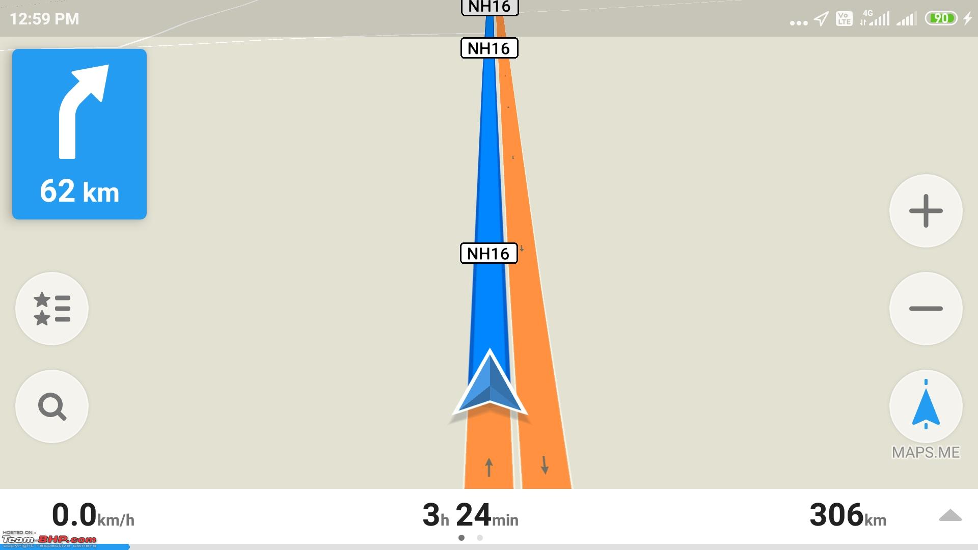
Maps.me - A completely open source app based on Open Street Maps
 The Good Things
- Initial download - It is minimal, for West Bengal its 45 MB only
- Business Search - Allows searching by business categories like grocery, banks, police station, etc with respect to current location
- Terrain - Absent in the previous options, but surprisingly it shows terrain details like nearby water bodies marked in a different color on the map so that while passing by you know whats around.
- Street names - Quite detailed and accurate, better than the above ones
- Current Speed Indicator - Available but without speed limit indicator.
- Local Guide - Surprisingly it does provide a local guide feature with additional download that shows the places of interest around current location.
The not so Good Things- Address Search - Poor capability, most of the time it will return only by Area Names or important landmark / establishment in the vicinity only.
- Traffic - This is not evident, and as a result this also culminates in ending up with a completely unrealistic ETA for arrival at destination especially on long distance routes
- Local Business Search - Not up to the mark
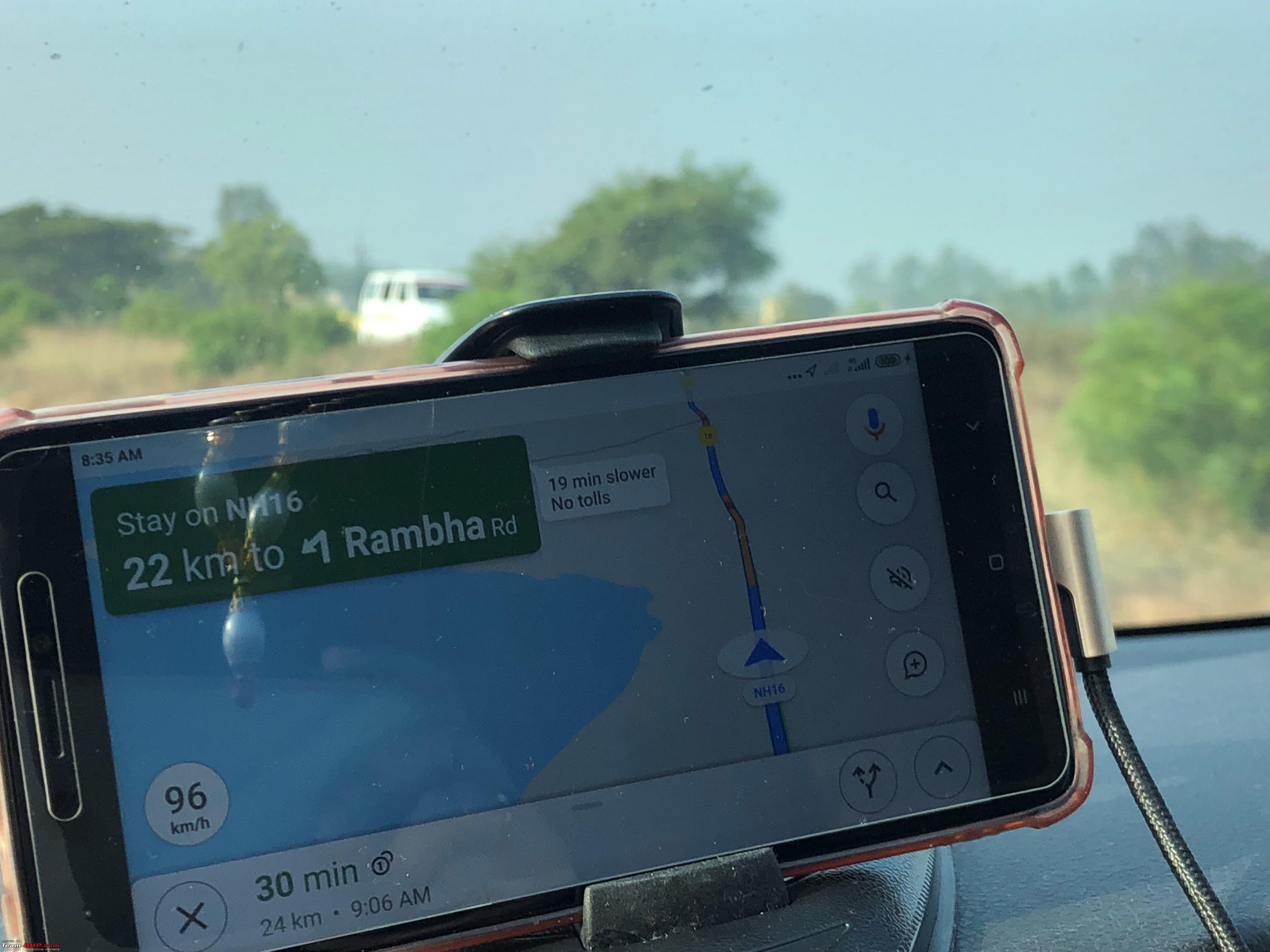
Google Maps - Needs no introduction, popular and for reasons

Well, this is the most widely used navigation app in India because of some basic yet highly important areas that Google Map has ticked all the right boxes as compared to contemporary options and moreover what is offers is accurate and for free of cost even if not the most feature rich.
What works in its favour- A Realistic traffic / road delay information overlayed on the road and results in reflecting a very accurate ETA for reaching the destination, it is complex to calculate during city drives and Google does it great and in a city what more can you ask for. Moreover this works great on highways too and probably is the most important reason why people use this.
- The level of details on the map are the most with interior lanes, shortcuts, service lanes and local business all put in one option and gets regularly updated too, the advantage google may be getting here is the abundance of android devices with Location services turned on unknowingly and in a way helps reporting to google routes traversed and congestion even without an active reporting service.
- The Maps do support downloading offline version and that too for custom route
- Searching by Local business name is the best among all other options, guess this is because the same platform is open for businesses to plot themselves on the map
- Excellent timeline feature for easy retrieval later on of trips and routes taken months back.
- Allows exploring local restaurants, places of interest from the current location
- The best use of back button, believe me this is very useful feature, for example if you are using some of the other apps and amidst a navigation hit the back button, the same is treated as Exit App and not End Navigation unless your fiddle around with the Menu options and tap the right point on the screen, very clumsy and inconvenient while you are driving.
- Night Mode present, although this exist in other apps too, useful for dimming the background to dark theme so that glare to the eye is minimal while driving in evening.
- The biggest and most active crowd sourced community of users updating information like road diversions, closure, accidents regularly and that is overlayed on routes and used in calculating best routes / ETAs to reach destination.
What can still improve- The road event reporting does not allow reporting speed cams, may be in alignment with the interest of law / road safety.
- At times diversions are outdated, and if you are being shown a diversion make sure to look ahead in front of the road and zoom out the map to see if the route merges back to the main road after some distance and take an informed decision.
- No support for music controls, yet.
- The Lane assist feature is present but its so insignificantly presented with a bent arrow that you at times you may miss taking the correct lane unless the voice guidance provides you with additional tips or you slow down / halt and zoom in on the map to understand for yourself.
- The most annoying thing one will find, in-spite of selecting the type of vehicle like 2 / 4 wheeler, at times the maps will guide you aggressively into narrow roads / markets that you may end up feeling disgusted getting into and at best are suitable for 2 wheelers only or cabs at the most. There should be an aggressiveness of route level setting somewhere
 depending on which Google must not detour to narrow roads even if that saves some time for the sake of a pleasant drive.
 - Better voice control driven routing operations to provide end to end hands free experience, it is available to an extent with Google Now enabled, I recommend instead of running maps standalone better to download Android Auto on the phone and run through it even if your car infotainment does not support Android Auto.
Some notable predecessors
It would be injustice not to mention
Nokia Maps in this context as it revolutionized the app driven navigation experience in India with its great offline maps and they were the pioneers of app based turn by turn navigation in a user friendly fashion with an Indian voice and with a great attempt towards providing address based search although not completely accurate at times, yet for the time it was great.
They were rightly superseded by
Here Maps in Lumia devices thereafter which again was an upgrade over the Nokia Maps in providing the first of its kind augmented reality like option of exploring a place by turning the camera around a street point and seeing businesses plotted on the live camera image. Of course their business search and address search was not that great so some 3rd party apps emerged in due course based on Google APIs which would allow searching the business / address a lot more accurately (as Google had already splurged ahead in this area by that time) and pass on the geocodes to the Here Maps to do the route navigation only. Not the most intuitive way but used to work great for some time and had the advantage of specifying private / paid Google API keys so that usage remains private too.
I do not have first hand experience with
MapMyIndia or
Garmin mobile navigation apps so encourage BHPians to pitch in with more thoughts and remarks.


 1st March 2020, 12:47

 (30)
Thanks
(30)
Thanks


 . Google Maps dominates the scene because it's so damn good + free + dependable traffic updates + Android's market-share.