Team-BHP
(
https://www.team-bhp.com/forum/)
That right, but the traffic torture on Mysore road can be testing...
Quote:
Originally Posted by paragsachania
(Post 3744683)
Yes. This has been mentioned by Satya earlier. Buses have got the hang of this route and the conditions remain good almost throughout and a not-so-famous and a non-regular route (CR Patna-Kushalnagara).
This is the rainy season I would avoid all such roads as many would be taking those options these days. All thanks to the joke called Shiradi Ghat repairs.
|
Quote:
Originally Posted by lohithrao
(Post 3744678)
Airavata is taking chanarayapatna route, after kushalnagara they go via chanrayapatna and then the usual Kunigal route. road is supposed to be good and it takes about 8hrs. next time i drive to Bangalore i think i will take this route.
|
Yes, Buses make it in 8 hours. Pity they don't get the 15 min break they used to have earlier. The max they stop is 5 minutes now. Have become used to seeing private bus drivers cover up the fatigue with ample doses of Gutka and Cigarette.
Quote:
Originally Posted by Samurai
(Post 3744247)
Holy Cow! We are already in July and Shiradi is still not open... This must be the longest clousure of such a major road. One could have built a brand new Road in some countries in the same time.
|
Pity there is no public outrage. Personally feel this is done with such impunity because of the lack of will among Mangalorean folks to fight for something meaningful! :Frustrati Peace loving community, they say. Any other place in India and by now a couple of ministers/officers would be held at ransom.
Planning on a 3 AM start tomorrow morning to Mangalore. A function to make it to there. Good food awaits lol:
Just did Blore - Mlore today via CRpatna - H.Narsipura - Arkalgud - Shanivarasanthe - Somawarapete - Madikeri.
Roads are good throughout except for a small patch after exiting Arkalgud towards Mallipatna.
This route is not recommended if driving in the dark. There could be surprises like a tree branch or a pot hole out of nowhere.
Managed to do this in 7 hours with a small 10 min wash room break. Thanks to Ramadan and had to reach Mlore by 1 pm for friday prayers.
Folks, I'm planning a drive to Shirva next weekend and need an update on the best route to take. I plan to leave Bangalore early (3:00 AM) and like I have in the past, I will be splitting the driving duties with my wife who is a very good driver too. Which is the best route to take?
Quote:
Originally Posted by gpa
(Post 3747041)
Folks, I'm planning a drive to Shirva next weekend and need an update on the best route to take. I plan to leave Bangalore early (3:00 AM) and like I have in the past, I will be splitting the driving duties with my wife who is a very good driver too. Which is the best route to take?
|
I dont think there is any option but Charmadi.
Hassan-Belur-Kottigehara-Charmadi-Belthangady-Bajagoli-Karkala-Belman-Shirva
Quote:
Originally Posted by ampere
(Post 3747051)
Hassan-Belur-Kottigehara-Charmadi-Belthangady-Bajagoli-Karkala-Belman-Shirva
|
Thank you, ampere. How long will this route take? Would you happen to know the condition of roads this route?
Quote:
Originally Posted by gpa
(Post 3747059)
Thank you, ampere. How long will this route take? Would you happen to know the condition of roads this route?
|
Total : ~400km (~8 hours)
- About 3 hours to Hassan. (180km, 4-lane)
- 30-40 minutes to Belur
- 60-80 minutes (Belur to Kottigehara) Narrow single lane road
- 90 minutes to max to cross Charmadi to Belthagngady
- 90 minutes to Belman via Bajagoli/Karkala
Quote:
Originally Posted by gpa
(Post 3747059)
Thank you, ampere. How long will this route take? Would you happen to know the condition of roads this route?
|
If you plan a smart start, you don't really need to worry about the road conditions. This includes even the narrow sections on Charmadi ghats. Rest of the sections are not narrow as long as you know how to manage the wheel on single lane highway.
Of course, the narrowest would be one section soon after you cross a Temple on Charmadi Ghats but this is just 50 meters where only one car/Bus can pass.
All the 11 hair pin bends is where you practice & follow right of way for oncoming vehicles, specially buses and trucks. Else its a good road anyway.
Since you mention its a weekend start, ensure that you leave at least by 3:30AM to beat the usual rush. By this time, you will not face traffic towards Charmadi and will be much peaceful and at the same time, maximum night bus traffic would have passed Belur/Hassan anyway.
The road conditions are good barring few sections in Charmadi Ghats, specially the 11 Hair pin curves where you only need to negotiate slower than usual due to soil scattered all over the curves.
Belur will only be a 3 hours drive. Mudigere "Hand post" (as you don't enter Mudigere for this anyway) will be 30 minutes.
The next section depends on the weather conditions too. Rains &/or Fog can also slow you down.
If I were you - I would pick Kottigehara-Kalasa-Kuduremukha-SK Border-Bajagoli-Karkala option simply because this route will have less traffic.
Budget anything between 6-7 hours max for this entire circuit irrespective of whichever option you take.
PS: I am assuming that you are aware of the terrain of road and facilities around this section (After Belur till Ujire or Belur till Kalasa). This is not the
preferred route by many only because you don't have good restaurants or CCDs even though there are ample decent options to compliment when in need. So if you are very particular about super clean rest rooms and good quality restaurant like ambiance every 2 hours, then this route might disappoint you.
Quote:
Originally Posted by paragsachania
(Post 3747158)
If I were you - I would pick Kottigehara-Kalasa-Kuduremukha-SK Border-Bajagoli-Karkala option simply because this route will have less traffic.
PS: I am assuming that you are aware of the terrain of road and facilities around this section (After Belur till Ujire or Belur till Kalasa).
|
Aren't there many forks/deviations from kottigehara > kalasa? Are they clearly marked these days? I remember once, traveling in the dark, getting confused and lost coz there weren't proper road signs/boards.
Quote:
Originally Posted by ampere
(Post 3747147)
Total : ~400km (~8 hours)
- About 3 hours to Hassan. (180km, 4-lane)
- 30-40 minutes to Belur
- 60-80 minutes (Belur to Kottigehara) Narrow single lane road
- 90 minutes to max to cross Charmadi to Belthagngady
- 90 minutes to Belman via Bajagoli/Karkala
|
Thank you, for these details ampere.
Quote:
Originally Posted by paragsachania
(Post 3747158)
If you plan a smart start, you don't really need to worry about the road conditions. Rest of the sections are not narrow as long as you know how to manage the wheel on single lane highway.
|
Wow! Thank you for the detailed response Parag. You are the true conquerer of the Indian highways with all your driving. I have always admired your spirit for driving. :thumbs up Although I don't come close to your experience on highways, I have driven a fair bit and am confident of a drive on a single lane highway.
Quote:
Originally Posted by paragsachania
(Post 3747158)
Since you mention its a weekend start, ensure that you leave at least by 3:30AM to beat the usual rush.
|
I start all my long highway drives early. Since I've never driven on this route I'm hoping this early start will help this time too.
Quote:
Originally Posted by paragsachania
(Post 3747158)
If I were you - I would pick Kottigehara-Kalasa-Kuduremukha-SK Border-Bajagoli-Karkala option simply because this route will have less traffic. PS: I am assuming that you are aware of the terrain of road and facilities around this section. So if you are very particular about super clean rest rooms and good quality restaurant like ambiance every 2 hours, then this route might disappoint you.
|
6-7 hours (for both routes) sounds okay and since I'm not familiar with this route I hence will stick to the earlier one which
ampere has also mentioned about. I recall reading on one of your threads that your hometown is Belur, which is why I guess you know so much about this route. Thank you again for your help. :)
Quote:
Originally Posted by JMaruru
(Post 3747229)
Aren't there many forks/deviations from kottigehara > kalasa? Are they clearly marked these days? I remember once, traveling in the dark, getting confused and lost coz there weren't proper road signs/boards.
|
At Kottigehara not sure if Kalasa is marked. But you should see a turning for Balehonnur. Thats how I mark them on my GPS.
Quote:
Originally Posted by gpa
(Post 3747233)
6-7 hours (for both routes) sounds okay and since I'm not familiar with this route I hence will stick to the earlier one which ampere has also mentioned about. I recall reading on one of your threads that your hometown is Belur, which is why I guess you know so much about this route. Thank you again for your help. :)
|
Kottigehara-Balur-Kalasa-Samse-Kudremukh-Bajagoli section is a bit involved in the sense, you need to be aware of where to turn. But other wise its a nice route via Kudremukh.
Quote:
Originally Posted by ampere
(Post 3747236)
At Kottigehara not sure if Kalasa is marked. But you should see a turning for Balehonnur. Thats how I mark them on my GPS.
Kottigehara-Balur-Kalasa-Samse-Kudremukh-Bajagoli section is a bit involved in the sense, you need to be aware of where to turn. But other wise its a nice route via Kudremukh.
|
The deviation towards kalasa, can be made easily at kottigehara but NOT the 3 or more deviations/forks further until kalasa.
It is NOT one single road towards kalasa and in the dark, it becomes much more difficult.
Quote:
Originally Posted by JMaruru
(Post 3747250)
It is NOT one single road towards kalasa and in the dark, it becomes much more difficult.
|
+1 Thats why even I mentioned the route being a bit involved. Its not easy for a first time dive. One will need to ask people for directions.
Quote:
Originally Posted by JMaruru
(Post 3747229)
Aren't there many forks/deviations from kottigehara > kalasa? Are they clearly marked these days? I remember once, traveling in the dark, getting confused and lost coz there weren't proper road signs/boards.
|
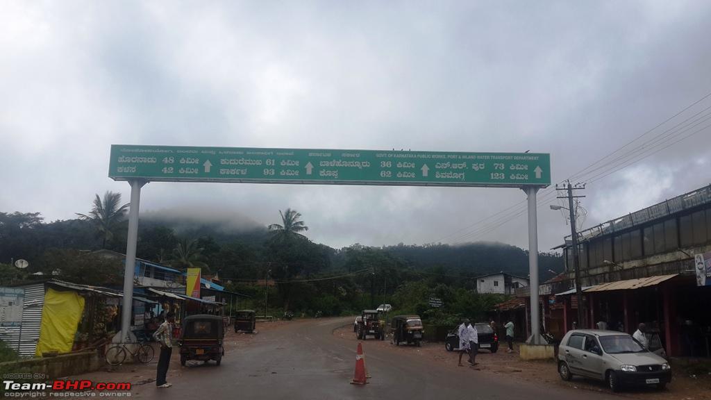
Kottigehara is well marked right at the Town. Plus you wont miss that Intersection where on the right hand side you have a huge signage like this:
The only tricky one will be after Balur. The road forks into two and for Kalasa you almost take a left handed Hair Pin Curve. This is not a SH and I remember the signage is marked in Kannada for Kalasa (and its a MDR). Caching maps will certainly help or even using a dedicated GPS device otherwise.
Last one of course is that vital turn for Kuduremukha inside Kalasa for which you first pass the temple on the right hand side and keeping temple right at the back you head for not more than 300 meters on the main road and there is a small Gully (that opens up ahead) with a metal sign for Kuduremukha.
Past Kuduremukha where this SH Joins NH13 (where right leads to Sringeri) also is very well marked.
Beyond this you get good network coverage and I am sure you can follow the maps, specially when crossing Karkala and getting onto the road for your final destination.
Some times we do worry much. This is something we all did in the past (asking people around) but now we have maps.
Remember the via points and you for sure we can have a smooth run.
I think we are simply making things look super complex for gpa here :)
Familiar scenery but unfamiliar road.
Shiradi ghats are set to open on Aug 1st as per the latest news report in Daijiworld.
| All times are GMT +5.5. The time now is 19:50. | |