Team-BHP
(
https://www.team-bhp.com/forum/)
- -
All Roads to Kerala
(
https://www.team-bhp.com/forum/route-travel-queries/27690-all-roads-kerala-820.html)
Quote:
Originally Posted by Mnjdnght
(Post 4702300)
I am not sure if this is a day-time-only restriction.
|
This is
not a day time restriction. There is a elevated highway / flyover construction going on starting ukkadam till the palakkad road junction (that deviates to Pollachi and Palakkad).
Until the work is complete the restriction remains same. Also, I do not think it is a wise decision to enter the CBE city and go thru the traffic. The traffic in the CBE city is getting horrible these days, except sundays.
Instead the LnT bypass is a good option. Though distance is more it gives a pleasant journey IMHO.
I have been travelling to my hometown (Alleppey) regularly, and have always taken the below route:
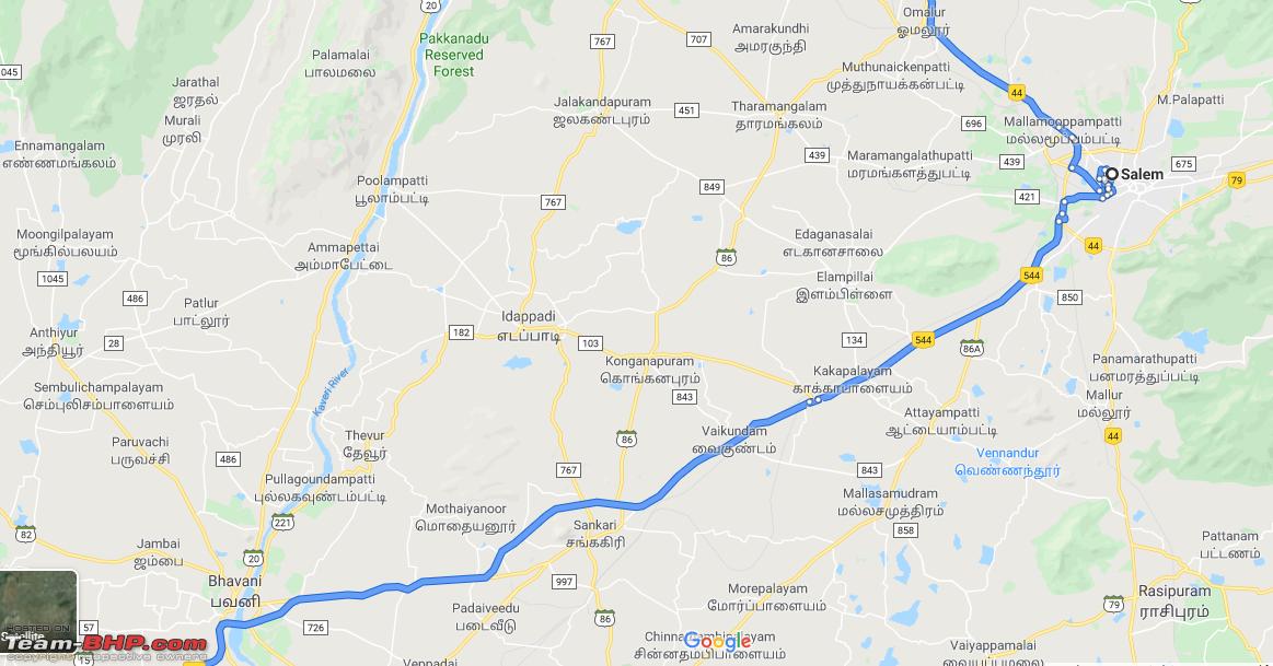
BLR > Krishnagiri > Dharmapuri > Omalur > Salem > Vaikundam > Vijayamangalm > and then on (Basically NH544) 
GMaps also suggested me this route, always. But today I was casually checking GMaps (as I have another trip coming up in 2 weeks. For some strange reason, GMaps is not suggesting the above route anymore. It basically is suggesting to skip Salem, and take the below route:
BLR > Krishnagiri > Dharmapuri > Omalur > Tharamangalam > Idappadi > Sankari > and then continue from the old route (mentioned first) 
- Any idea what is wrong with the first route, that GMaps has stopped suggesting it?
- Has anyone used this latest route (second one) recently? What is the condition of roads?
- Is this new route safe (as I will be travelling @ 3 AM)?
Quote:
Originally Posted by Repsol
(Post 4704183)
I have been travelling to my hometown (Alleppey) regularly, and have always taken the below route: BLR > Krishnagiri > Dharmapuri > Omalur > Salem > Vaikundam > Vijayamangalm > and then on (Basically NH544) Attachment 1941231
GMaps also suggested me this route, always. But today I was casually checking GMaps (as I have another trip coming up in 2 weeks. For some strange reason, GMaps is not suggesting the above route anymore. It basically is suggesting to skip Salem, and take the below route: BLR > Krishnagiri > Dharmapuri > Omalur > Tharamangalam > Idappadi > Sankari > and then continue from the old route (mentioned first) Attachment 1941232 - Any idea what is wrong with the first route, that GMaps has stopped suggesting it?
- Has anyone used this latest route (second one) recently? What is the condition of roads?
- Is this new route safe (as I will be travelling @ 3 AM)?
|
By following the 2nd option suggested by Google, you will be avoiding paying toll at Omalur and Sankagiri.
I have traveled before on this stretch. Good 2 lane roads all the way. Infact you can try one more option as well
Via Thoppur, Mecheri, Nangavalli, Jalagandapuram and Edappadi to Sankagiri.
There is actually no need to touch Salem to go to Alappuzha.
Quote:
Originally Posted by Repsol
(Post 4704183)
- Any idea what is wrong with the first route, that GMaps has stopped suggesting it?
- Has anyone used this latest route (second one) recently? What is the condition of roads?
- Is this new route safe (as I will be travelling @ 3 AM)?
|
I did Bangalore-Coimbatore-Bangalore over the weekend and Google maps didn't show the Salem-NH544 route. However since I was doing this after a long time I stuck to NH544
I always use navigation while driving and this did cause a bit of confusion while entering Salem but the moment I crossed the first flyover suddenly the Maps shifted to the NH544 route and the journey time reduced by ~20 mins.
I think Gmaps still thinks there is a blockade in Salem due to flyover construction while there is only one flyover still under construction. The biggest surprise was Maps continuing to show the other route even after crossing the Omalur toll which was a breeze with fastag.
Stick to the NH544 route especially with flooding in Bhavani river. Coimbatore-Salem was a bit of a nightmare on Sunday with crazy heavy rains although thankfully there was not much water logging on NH544.
Quote:
Originally Posted by Repsol
(Post 4704183)
- Any idea what is wrong with the first route, that GMaps has stopped suggesting it?
- Has anyone used this latest route (second one) recently? What is the condition of roads?
- Is this new route safe (as I will be travelling @ 3 AM)?
|
Nothing is wrong with the first route, go ahead with it. It is possible that at the time you did the search, Google found a traffic bottleneck within Salem city limits and routed you around that. Google always uses instantaneous conditions to suggest a route (It clearly says "Fastest route now due to traffic conditions", which you can avoid by using the "Set depart or arrive time" option).
I have driven the second route several times when "Toll Avoidance Routing" was a thing here. :-) It is generally a good road - normal TN SH standards - with many small towns and villages along the route. Being so close to Salem it is fairly well-populated too, so there is not much of a safety issue in taking that route.
Quote:
Originally Posted by suresh_gs
(Post 4704221)
By following the 2nd option suggested by Google, you will be avoiding paying toll at Omalur and Sankagiri.
I have traveled before on this stretch. Good 2 lane roads all the way. Infact you can try one more option as well
Via Thoppur, Mecheri, Nangavalli, Jalagandapuram and Edappadi to Sankagiri.
There is actually no need to touch Salem to go to Alappuzha.
|
Quote:
Originally Posted by anandhsub
(Post 4704242)
I did Bangalore-Coimbatore-Bangalore over the weekend and Google maps didn't show the Salem-NH544 route. However since I was doing this after a long time I stuck to NH544
I always use navigation while driving and this did cause a bit of confusion while entering Salem but the moment I crossed the first flyover suddenly the Maps shifted to the NH544 route and the journey time reduced by ~20 mins.
I think Gmaps still thinks there is a blockade in Salem due to flyover construction while there is only one flyover still under construction. The biggest surprise was Maps continuing to show the other route even after crossing the Omalur toll which was a breeze with fastag.
Stick to the NH544 route especially with flooding in Bhavani river. Coimbatore-Salem was a bit of a nightmare on Sunday with crazy heavy rains although thankfully there was not much water logging on NH544.
|
Quote:
Originally Posted by binand
(Post 4704262)
Nothing is wrong with the first route, go ahead with it. It is possible that at the time you did the search, Google found a traffic bottleneck within Salem city limits and routed you around that. Google always uses instantaneous conditions to suggest a route (It clearly says "Fastest route now due to traffic conditions", which you can avoid by using the "Set depart or arrive time" option).
I have driven the second route several times when "Toll Avoidance Routing" was a thing here. :-) It is generally a good road - normal TN SH standards - with many small towns and villages along the route. Being so close to Salem it is fairly well-populated too, so there is not much of a safety issue in taking that route.
|
Thanks for all the responses :thumbs up
Based on the above inputs, I think I will stick to my tried and tested route 1 (NH544 via Salem), as I feel more confident with that. I would have surely took the second route and explored, had I been travelling alone, but I have my family with me, and don't want to take any chances with an unknown route.
Google maps plays some trick while driving from Avinashi to Palakkad direction through NH just before L&T road entry toll gate. Maps suggestion is to take the left turn and get on to the exit bridge towards Coimbatore instead of continuing straight towards L&T. Once you get down from the bridge and continue towards the city, it will direct you through a narrow left lane that joins before the 2nd toll gate in L&T.
Being happy about avoiding the mess of L&T road and thinking it is directing to drive through the City since it was off peak hours, I took the suggestion once. I found myself to be back on L&T road in no time, and felt I could have only wasted few minutes .
Google is consistently showing this route during last few trips and I have been ignoring it. I heard same story from another person and would like to know if others have experienced same
Quote:
Originally Posted by gadadhar
(Post 4704968)
Google maps plays some trick while driving from Avinashi to Palakkad direction through NH just before L&T road entry toll gate. Maps suggestion is to take the left turn and get on to the exit bridge towards Coimbatore instead of continuing straight towards L&T. Once you get down from the bridge and continue towards the city, it will direct you through a narrow left lane that joins before the 2nd toll gate in L&T.
Being happy about avoiding the mess of L&T road and thinking it is directing to drive through the City since it was off peak hours, I took the suggestion once. I found myself to be back on L&T road in no time, and felt I could have only wasted few minutes .
Google is consistently showing this route during last few trips and I have been ignoring it. I heard same story from another person and would like to know if others have experienced same
|
Yes, this is exactly the same for the past 2 years whenever I travel to Alleppey. I fell for it once (first time), and then onwards, I always go straight to L&T, ignoring what GMaps says. No point in taking that left, and then again go ahead a few meters to take another left to join back on L&T
Quote:
Originally Posted by gadadhar
(Post 4704968)
Google maps plays some trick while driving from Avinashi to Palakkad direction through NH just before L&T road entry toll gate. Maps suggestion is to take the left turn and get on to the exit bridge towards Coimbatore instead of continuing straight towards L&T. Once you get down from the bridge and continue towards the city, it will direct you through a narrow left lane that joins before the 2nd toll gate in L&T.
|
Google does that every time and I fell for it once. I guess gmap thinks you pay less toll if you skip one booth.
Quote:
Originally Posted by Repsol
(Post 4705056)
No point in taking that left, and then again go ahead a few meters to take another left to join back on L&T
|
Agreed that it is an absolute waste of time and energy :)
Quote:
Originally Posted by ike
(Post 4705412)
Google does that every time and I fell for it once. I guess gmap thinks you pay less toll if you skip one booth.
|
Funny part is there is no difference in toll between the first 2 booths.
How are the road conditions on the Bangalore-Salem-Coimbatore-Palakkad-EKM stretch? Have the usual year-end trip coming up in a couple of weeks. How is Kuthiraan traffic now?
Quote:
Originally Posted by Sunil2307
(Post 4708723)
How are the road conditions on the Bangalore-Salem-Coimbatore-Palakkad-EKM stretch? Have the usual year-end trip coming up in a couple of weeks. How is Kuthiraan traffic now?
|
Bangalore-Palakkad is fine. As per recent posts, Kuthiran is fine and was patched up. Don't know how road conditions beyond Kurhiran are.
Quote:
Originally Posted by NPV
(Post 4708743)
Bangalore-Palakkad is fine. As per recent posts, Kuthiran is fine and was patched up. Don't know how road conditions beyond Kurhiran are.
|
Drove till Kalady last weekend, Kuthiran to Angamaly is in excellent shape except for the half complete 4 lane stretches near Pattikad.
You can expect some confusion and congestion in Paliakkera toll plaza once the Fastag is mandated in all except one lane
Folks, Kindly suggest route and road conditions for the following:
1. Chinnakanal to Kumily. Google suggests via Pooppara-Undumbanchola-Vandanmedu. It skips Nedumkandam. How is this road?
https://goo.gl/maps/Pgf6bvucYuZaP7U67
2. Kumily to Ernakulam. Google suggests via Kuttikkanam-Kanjirappally-Pala. I guess this is pretty good road. Anything to watchout for.
Thanks!
Quote:
Originally Posted by bejoy
(Post 4711967)
Folks, Kindly suggest route and road conditions for the following:
2. Kumily to Ernakulam. Google suggests via Kuttikkanam-Kanjirappally-Pala. I guess this is pretty good road. Anything to watchout for.
Thanks!
|
Kuttikkanam - Kanjirappally - Ponkunnam - Pala would be a better choice, imo.
| All times are GMT +5.5. The time now is 08:00. | |