| |
|
Originally Posted by Sree73
(Post 4075637)
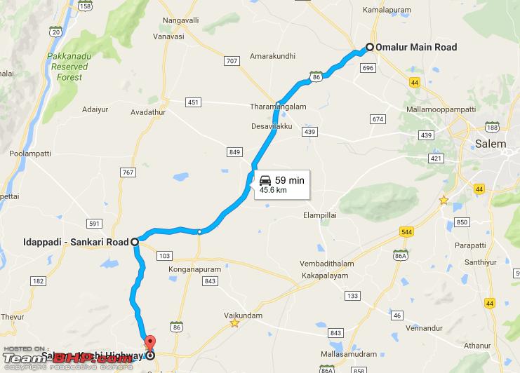
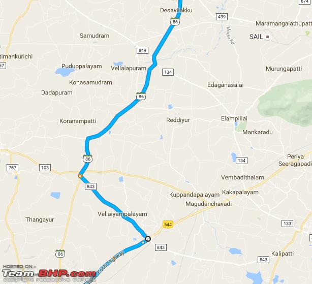
Here you go with the map. |
|
Originally Posted by Sree73
(Post 4075597)
Started at 3:15AM from Whitefield and Reached home (496KM) @11:15AM with a 30 minutes break for breakfast. Overall FE of 22.7km/l. (S-Coss 1.3). |
|
Originally Posted by arjithin
(Post 4075830)
496 is the exact km from my home at Whitefield to my parents home @ chalakudy. :) Where exactly was your destination ? Looks like you took the route very sedately and that is reflected on your FE. |
|
Originally Posted by Sree73
(Post 4075637)
Here you go with the map. |
|
Originally Posted by binand
(Post 4075710)
Note that at the bottom left corner, Google Maps routes you through some not-so-ideal roads; the route most of us here prefer is via the outskirts of Idappadi town. |
|
Originally Posted by pramodpk
(Post 4076070)
But it doesn't make sense to take this route while going as it is slightly slower. |
|
Originally Posted by binand
(Post 4075710)
Note that at the bottom left corner, Google Maps routes you through some not-so-ideal roads; the route most of us here prefer is via the outskirts of Idappadi town. This is the faint white line in your map which starts from the kink in the blue line just above the "8 hr 23 min" marker. |

|
Originally Posted by ankan.m.blr
(Post 4076554)
Hi T-BHPians, need some help with the following route : Hunsur-Nagarhole forest- Kutta-Thirunelli. We want to go to Kutta from Hunsur by crossing Nagarhole forest as shown in the map. In very early morning. My doubts are : 1. Google maps, by default, shows the route as Hunsur-Gonikoppa-Kutta (and not through Nagarhole forest). Is the forest route closed? If its open, how's the road condition now. I have done this route in 2014 and road inside forest was patchy & potholed. 2. We (me & 2 friends, all guys) are planning to start at night from Bangalore and reach forest gates at 6-00 AM (thats the time the gates open I guess). Which means we need to cover from Hunsur to the forest gates at 4-00 AM / 5-00 AM. Is the route safe to travel at that time? 3. Why google maps isn't depicting Nagarhole forest in green color in the maps? All forests are usually sown in green. stupid: this is bugging me |
|
Originally Posted by Rajeevraj
(Post 4076562)
1. Did you do the google search now? The forest road is closed from 6pm-6am. So if you search with the 'Leave Now option' in this time window, it is going to route through Gonikoppa-Kutta, which is open at night also. If you chose the leave at say 6am in maps, it will route you through the forest. I think the road condition will be similar to 2014. I don't recall it being relaid recently (May be wrong though, I have not personally take this route) |
| 2. 5am should be fine. Don't think you need to be worried-especially since it is an all guys gang. |
| 3. Interesting point. Not sure why. Definitely used to show green earlier. Maybe some temporary glitch?The forest is still definitely there. :) |
|
Originally Posted by Sree73
(Post 4075597)
Did a Bangalore - Thrissur trip yesterday. (15th Oct). Pleasant drive. Took the normal Salem-Coimbatore route Returning on Tuesday. |
|
Originally Posted by nitinbose
(Post 4076839)
Many of the highways in south India appears closed, when you browse Google maps. |
|
Originally Posted by binand
(Post 4076971)
You need to show something. Which highways are closed? |
|
Originally Posted by nitinbose
(Post 4076839)
Many of the highways in south India appears closed, when you browse Google maps. Is this for real? What could be the reason if so? |
|
Originally Posted by binand
(Post 4076971)
You need to show something. Which highways are closed? |
|
Originally Posted by nitinbose
(Post 4077006)
Here are some screenshots attached, indicating many of the highways as "closed". |
|
Originally Posted by bejoy
(Post 4077010)
One of them would be the Gundlupet - Muthanga - Bathery route. GMaps routes it through Gudalur. It has been so for a long time. Not sure why. The route via Muthanga is open and perfectly fine. |
| All times are GMT +5.5. The time now is 05:40. | |